Hey fellow blog fans!
Yesterday (June 18) I descended the east rim of Zion Canyon and completed the Hayduke Trail. Caron was there to celebrate at the Weeping Rock springs after she had done some dayhiking further up the canyon. We visited the "Whiptail Grill" in Springdale, UT but it wasn't the greasy burger joint I was hoping for (like almost all of the restauraunts in Springdale, it is making an attempt to reel in the yuppies by offering an upscale menu of overpriced, southwestern-influenced cuisine). We eventually worked our way out of yet another public zoo/national park scene and ended up in our favorite little enclave of Escalante, Utah.
The final section was a real mood-swinger. After ascending Kanab Creek Canyon (a final and unique tour of the Grand Canyon's geologic layers), we found ourselves on the arid and desolate Arizona Strip. Fortunately, Caron's vehicle support made this stretch more do-able than it would have been otherwise. Before finally yielding to the Vermillion Cliffs and more Zion-like landscape, the road passes through the very strange and somewhat creepy little corner of northwestern Arizona claimed long ago by the Mormon fundamentalists. There they freely practice polygamy, welfare fraud, and a host of other anti-social activities. I just couldn't get out of there fast enough and the walk turned into a marathon sprint across this isolated and wide-open landscape traversed by a confusing maze of BLM roads. I was happy to see the East Fork Virgin River canyon and quickly disappeared into it only to re-emerge finally at the trail's end in Zion.
The end of a long trail is always bittersweet for me. While on the trail, one anticipates how nice it would be to break away, reflect on the accomplishment, and spend time with friends and family. But this anticipation also carries a sort of emotional sadness about leaving an environment which has become familiar and comfortable-- far removed from the alien surroundings it seemed to be at the start of the journey. On the last two days, I found myself paying more attention to the little details of the trail that were taken for granted while I entertained no thoughts of finishing. The birds and their diverse language of calls, the lizards and their frantic predator avoidance behavior, the cliffrose now forming fruit from the blossoms of two weeks ago, the showy flowers, the sound of the wind roaring up a canyon and dissipating in the branches of the tall pines-- all contribute to make daily trail life so different from time spent in the confines of modern human society.
The blog will continue right up to the final days just described. This blog was much more than a diary and it took far longer than I originally thought to write and upload each chapter. Some of the remaining chapters are partially complete (an oxymoronic statement to be sure) and I'll upload them very soon as I will have full access to a computer while visiting my mom in Durango. The remaining chapters are as follows:
Playing the Slots (from Escalante to the Willis Creek Narrows)
A Three-Notch Mule (from Willis Creek through Bryce and on to the Grand Canyon rim)
The Walls of Time (The journey through the Grand Canyon and out through Kanab Creek)
The Road to Zion (Across the Strip and into Zion National Park)
Stay tuned and thanks for keeping up with the blog on this journey of a lifetime!
Whiptail (sadly, now off the trail)
Friday, June 19, 2009
Sunday, June 14, 2009
Play Rock Match 2!!!

Many easily recognized landforms and rock formations along the Hayduke Trail have been given official names, meaning that the name might appear on a map. Often, the local outdoor crowd will ascribe an unofficial name to a landmark formation. For example, the locally famous landmark of the inner Grand Canyon, pictured left, is very aptly named "The Battleship".
The imagination of the long-distance hiker is frequently consumed with identifying and naming rock formations along the trail. This activity is not simply born of the sheer monotony of marching briskly across the terrain day-in and day-out. Rather, the terrain itself is replete with mesmerizing artifacts of the weathering of stone that stimulate the imagination in unpredictable and fun ways.
Due to the overwhelmingly positive nature of the many, many comments left in the original Rock Match, we are uploading a new, more challenging, and R-rated version called "Rock Match 2". See if you can correctly match the list of unofficial names below to the letter title of each picture that follows. When correctly matched, the letters will spell the two items most lavished by hikers at the end of a long trail such as the Hayduke. Good luck and thanks you once again for playing Rock Match!
__ The Duck Hunter
__ Atomic Fireball
__ Pierre, the arteeest
__ Decapitated sheep
__ "A woman drove me to drink and I didn't even have the decency to thank her"
__ The Goofy Catcher
__ The Construction Worker
__ Checkmate
__ Sunburned chichas grandes
__ "sit on my face and I promise to tell lies"
__ Tall woman flashing short man
__ A boy and his dog
__ Ape Krishna
__ The Mohican
O

DA

I

N

H

Q

E

S

AA

R

L

WE

T

U

Tuesday, June 2, 2009
The Call of the Escalante
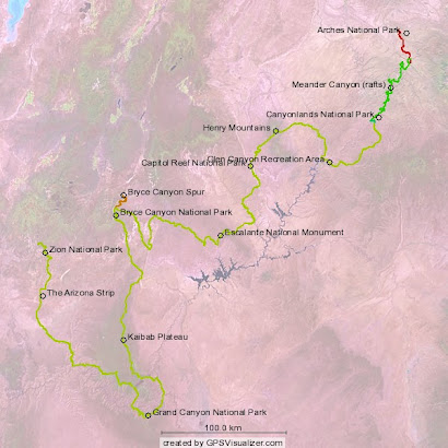
 Although the mileage contained in this section resides almost entirely within the Glen Canyon National Recreation Area, this section is mainly about the Escalante River drainage. The route leads ultimately into a 28-mile section of the river corridor, where the abundance of southwestern desert life should satisfy the biologist in all of us.
Having restocked our food and water supplies at the cache site, pared down our equipment, and relaxed in the shade for most of the day, we felt somewhat recharged as we continued briefly into the next section. The walk down Lower Muley Twist Canyon was easy on the legs and definitely easy on the eyes!
Day 24
Saturday, May 2
Start: Lower Muley Twist Canyon
End: Hall's Creek Canyon at the Red Slide
Miles: 11.6
We spent the night in one of the incredible alcoves of the Wingate sandstone, and awoke all too eager to commence our journey down the amazingly scenic Lower Muley Twist. Here the canyon cuts through the layers of the Waterpocket Fold in a most dramatic fashion. The 'big four' geologic layers of the upper Colorado Plateau are present in the canyon. In descending order of elevation, they are Navajo sandstone, Kayenta formation, Wingate sandstone, and finally the crumbly and erosive Chinle formation (if you haven't figured it out yet, geologic layers are named for the location of the prominent outcropping where they are officially described in the literature). We have seen and will witness again this easily recognized sequence many times along the Hayduke route.
Lower Muley Twist begins with the Wingate at the level of the wash bottom. It is a resistant layer that gradually forms extensive undercuts and dramatic alcoves along the canyon floor. In the larger of these, one gets the feeling of entering the mouth of a giant cavern. In a few alcoves, part of the roof of the massive overhang has collapsed, producing a small tunnel in the wash drainage. We took two such 'inner tours' on the way down and marvelled at the darkness and the vibrant acoustics inside. Just outside of one alcove, a male canyon wren was singing and using the natural amphitheater to amplify his song. Perhaps he will reel in more females who are initially hoping to meet up with some kind of super male. Then they just 'takes what they gets'. Hey, if it works, why not?
 The Navajo sandstone has not been removed or even significantly reduced by erosion in this canyon and is absolutely massive-- hundreds of feet in height. The giant, smooth vertical walls are a cross-section showing the intricate cross-bedding pattern of ancient wind-blown sand dunes (at that point in geological time, the pattern was produced by periodic shifting in the prevailing wind direction). The weathering pattern on the towering vertical faces assumes a variety of surreal shapes and textures (see "Dirty Devil" in the Rock Match game). Perhaps a giant Navajo shaman originally created an image that was just too life-like and then decided to shake it around a bit before placing it up for display. The grandeur nature of these giant sandstone walls can't be over dramatized or even adequately described. They dwarf the many stately cottonwoods along the canyon bottom, which in turn dwarf the humans standing agaze below them.
We found some good surface water just below one of these cottonwood groves further down canyon and decided to fill up there and have a quick breakfast. It would soon be time to exit this gorgeous place but we weren't in any big hurry to do so. Eventually the canyon cut down to the level of the Navajo and then we noticed it appearing now on both sides of the drainage, indicating the latter had pierced the massive sandstone wall at some point down canyon. Soon we found ourselves walking through these grand Navajo 'halls' and spilling out onto the massive floodplain of Hall's Creek.
 There we met a festive party of seven day hikers, most delighted to talk to two Hayduke hikers who had been pretty much out of the loop for a week or more. We learned of the discovery of Everett Ruess' body-- big news for those who appreciate literature born out of a sense of adventure in the American southwest. It turned out this group was heading to the Muley Tanks, as we were, to refill with water. Along the way, we learned that the Navajo sandstone of the Waterpocket Fold has many such 'tanks', where rainwater and snowmelt are contained in folds of the sandstone ('plunge pools') that retain water far longer than pools collecting on soil. The water stays fresh as there is not a great deal of sediment build-up. I noticed an abundance of newly hatched tadpoles lining the sandy bottom of the pools and endeavoring to avoid the predaceous aquatic beetle larvae that were searching for food along the pond's substrate. The tadpoles were most likely the larvae of the desert spadefoot toad, a remarkable little amphibian with a suite of adaptations enabling it to survive and reproduce in ephemeral water sources so typical of southwestern deserts.
We filtered water and continued chatting with the knowledgeable desert travellers. The building cumulus clouds finally managed to spit out a few raindrops so we headed into the large junipers for cover while we ate lunch. The storm quickly dissipated and we continued our march down the vast and open dry floodplains of Hall's Creek. More tadpoles were soon encountered further downstream where small pools of stagnant water began to appear beneath more deeply cut streambanks.
 I was happy to be finally entering the realm of the spadefoot toads on this desert quest. We noticed that in some pools there were larger tadpoles that were eating the smaller ones. Whether this was a case of interspecific (between species) predation or a genuine case of cannibalism remains undetermined since identifying tadpole species is beyond my expertise. However, the desert spadefoot has a remarkable adaptation for survival if pond conditions begin rapidly deteriorating via evaporation. If it appears that the life of the pond will be shorter than the necessary time needed to complete metamorphosis into a land-loving toad, some of the larvae transform into wide-mouthed carnivores and begin feeding off their smaller herbivorous brethren. Kind of dramatic, if not perverse, by human standards. But it's a manner of translating genes into the future that makes good sense from an evolutionary view. Desert spadefoot toads: the ULTIMATE amphibian!
 By late afternoon we found ourselves at the base of the "Red Slide", the aftermath of a massive collapse of the Wingate sandstone cliffs more than 2000 feet above. Our path would lead us up an old wagon track over the slide and into the Escalante River drainage. It was clearly too late in the day to begin this long ascent, so we found a relaxing campsite on a cottonwood bench perched above the larval spadefoots in the pools of Hall's Creek. The broken skies presented a dramatic backdrop of low-angle light playing onto the colors of the Red Slide rising steeply to the west. We rested easily as the light faded and the toads began their piercing trills-- a welcome reminder that the real life of the desert thrives by night.
Day 25
Sunday, May 3
Start: Hall's Creek Canyon at the Red Slide
End: Middle Moody Canyon
Miles: 13.0
Vertical gain: 2400 feet
We initiated the long arduous ascent up the Red Slide early in the morning and that put us atop the Waterpocket Fold and on the pass by lunchtime. What an amazing view we were treated to while enjoying a delicious chicken salad lunch. To the east we could resolve our passage across the Henry Mountains and through the intricate mesa/canyon system leading to the fold. Since our initial ascent of the fold up the Burr switchbacks, we had meandered significantly south as we descended the fold through Lower Muley Twist and now had just re-ascended it. New views of more expansive, sparsely inhabited landscape opened south toward Lake Powell. We took in this view with a sense of great accomplishment-- a visual record of the landscape through which we had ventured with some difficulty. Travelling such an intimate pathway offers the thru-hiker a different appreciation for this daunting landscape. We simply could not experience the same feelings had we merely done a short day hike up the Red Slide.
 We now turned our concern to what was below and to the west. The lonely, sprawling Escalante landscape offers a distinctly different aspect compared to that in the east. The reddish orange Wingate sandstone, on top of which we were now perched, clearly dominated the canyon country below. Our ultimate goal was to descend a few different drainages that would lead us directly into the Escalante River itself.
We descended, more or less unscathed, into the drainage of Middle Moody Creek, a shallow wash slicing through the maroon-tinted Chinle formation. Pools of standing water made their appearance about halfway down and occasionally formed short, flowing trickles between the pools. Surface water in many of the wash bottoms forms an alkaline, evaporitic crust that splashes over the canyon bottom. We have deduced first-hand that the thickness and general prevalence of this so-called 'desert caliche' soil is a good indicator of the alkalinity of the water. The present pools looked good enough for us so we began filtering a full load of water.
During this time we heard a deafeningly harsh trill emanating from a small rock near our water pool. The raucus set off another similar-sounding trill from a few feet away, though at a different and higher pitch. This was definitely an escalating competition of penetrating calls that echoed furiously off the walls of this tight canyon. When it finally abated, we could hear that the chorus had set off a cascade of trills both up and down the canyon. Those eventually stopped and the canyon returned to silence, occasionally interrupted by the reliable warbling of canyon wrens. It was indeed good to be back in the realm of the desert spadefoot toads! We eventually began seeing more and more of these curious little creatures hopping along the water line. As a bona fide toad, the adults are only drawn back to water when it is time to call in the females for breeding purposes. No one could ever guess that this bold and raucous sound would be made by onyl a two-inch long amphibian, and a very modest-looking one at that.
By the time we filled our water bladders, we had experienced several bouts of the noisy toad-calling competition. I even managed to induce a bout by sounding out a crude sounding facsimile of the toad's call. We left the tight canyon as it opened up before merging with the larger Moody Creek drainage. We located a campsite on a terrace above the wash, noting it was also the site of an old cowboy camp with its many odd-dimensioned and thoroughly rusted tin cans. As we drifted off to sleep I thought I heard more from the toads up and down the nearby canyons, but it may have just been mental reverberations from earlier in the day.
Day 26
Monday, May 4
Start: Middle Moody Canyon
End: Escalante River Canyon at Scorpion Gulch
Miles: 11.3
We arrived at the Escalante River junction shortly into the day's walk, after noting the greater prevalence of willows and tamarisks in adjacent Moody Creek. What a refreshing site to come upon this fast-flowing water, its bluish-green color setting off the more vivid greens of the dense riverine vegetation. The canyon walls were the unmistakable reddish-orange of the Wingate sandstone that dropped more or less vertically to the canyon floor. The canyon had a different sound and feel to it compared to the hot dry washes we had been travelling to get there-- all by the addition of fast-moving snowmelt rushing in from the highlands to the north.
We had anticipated that the 28 miles downstream in this river corridor would be quite different than what we had experienced so far in terms of canyon travel. We quickly surmised that crossing the river would be a constant occurrence as we attempted to stay on the flattest part of the primary river terrace, which switched from one side to the other in concert with the meandering river. Fortunately for us, the river appeared to be at a lower level than it had been even recently and was only at thigh-level at its deepest. This and the stable, gravelly bottom made the crossings facile, if not enjoyable as a partial escape from the canyon's hot air. In some cases, we walked down the river as the intended path when both willow-choked banks presented less desirable alternatives.
This was not an intolerable mode of travel, in fact it was refreshingly novel, as we made fairly good time and by day's end we had pitched our tent among some small cottonwoods near the confluence of Scorpion Gulch. The spadefoots and other amphibians were just begining their vocalizations so we felt it would be appropriate to build a small fire to dry out our footwear and stay out among the stars. We retired with a certain sense of serenity amid the constant gurgling of the river, interrupted periodically by the spadefoot's brash call of the Escalante.
Day 27
Tuesday, May 5
Start: Escalante River Canyon at Scorpion Gulch
End: Escalante River Canyon near Fool's Canyon
Miles: 12.5
 Somehow the role of the river as a viable alternative path downstream seemed different today as we resumed our downstream trek. The water appeared to have risen by about a half a foot but we weren't exactly sure of this; it probably was imagined on our part. Quicksand appeared more frequently in the quiet stretches of water causing us to sink in to crotch level in some places. This is not the Gilligan's island variety of quicksand, where the unfortunate jungle traveller eventually sinks below the surface leaving only his hat to record a rather dramatic end (of course this always happened to someone who had the solution to getting everyone off the island!). The Escalante quicksand is a thin, silty, organic mud that will only allow you to sink to crotch level but it can entrap you just the same, especially with the added weight of a pack. The level of danger depends on the water depth. You could get mired in it with your head under water, pinned by wet packweight, but that didn't seem too likely here.
Shortly into the day's journey I hit a patch of quicksand that pulled me into waist deep water and unfortunately flooded my hardy Nikon camera which I had foolishly failed to remove from its hip pouch. What an unfortunate turn this was as I had remained fully commited to a photographic record of every phase of this journey. At least Caron's waterproof Pentax was fully operational and would now be pressed into more frequent service. Despite this setback we moved forever downstream, but now sticking to more land-based routing down the river corridor, only crossing the river where riffles and rapids indicate that a stable, gravelly substrate lies below the moving water.
This change in our mode of travel down the river brought us more frequently into the realm of the collared lizard and of course my namesake, the whiptail lizard.
 The collared lizard is quite a character-- not the least bit fearful. The males boldly patrol their territories atop rocks where the females can take notice of their bright coloration. Their anti-predator tactics consist of an initially stubborn and aggressive stance (making them fun and easy to photograph) and eventually a quick and dramatic escape on two hind legs. Not unlike ol' T. Rex himself.
The whiptail lizard has a different strategy altogether. It will initially and deliberately direct the predator's attention into a bush by noisily hastening into it and then effect its escape via stealthily creeping out the backdoor. As a last resort it will run in a manner few lizards could ever match. Whiptails are extremely fast. If you can catch one, you are either faster or smarter than the snakes, coyotes, foxes, and birds all looking to make a meal out of this rather sleek reptile.
 We eventually noticed that the Wingate sandstone layer was gradually lowering and getting closer to the canyon bottom, despite the fact that the river should normally be cutting into and revealing the layers below the Wingate. This apparent anomoly is simply due to the fact the layers are not horizontal but display an obvious dip in the direction of the water flow, owing to a past geological uplift event. In the case of the Escalante River, the dip is quite a bit steeper than the river's gradient. This presented consequences for hikers moving downriver because the boundary between the erodable Chinle and the overlying Wingate was now closing in on the river banks from both sides of the canyon. Along this boundary, huge blocks of the overlying sandstone were cleaving off where the eroded siltsone below could no longer support its overbearing weight. As a result, we found ourselves clambering up and down huge, RV-sized sandstone boulders that blocked our path next to the river. In many instances, we were either forced to ascend up the eroded canyon walls to get around the obstacles or try to wade around the blocks through the deep pools they created. Many of the giant blocks had rolled directly into the middle of the river and had managed to collect quite an impressive mass of logs and large branches washed down by what were clearly magnificent flash floods. It brought to mind the nest of an extremely large and frightful hummingbird.
Our progress through this giant boulder field was slow and arduous, and travel downriver became a monotonous and repetitive puzzle-solving game whose current solution simply revealed the next puzzle in the series. This mode of travel was much different than that of the previous day where the giant boulders were conveniently perched so far above the river that we hardly noticed their presence. Despite this setback, we still managed to gain 12 miles on the river corridor before arriving at another superb campsite on a small beach. Although today's mileage was a hard-fought battle, we remained in good spirits due solely to the sheer beauty of this rugged and unique canyon. After a hot meal around a very small campfire, we pondered the possibility of actually getting out of the canyon tomorrow. It seemed wise not to dwell on it for too long as it was clearly becoming difficult to predict what new obstacles would be tossed in our way as the river worked its way further south.
Day 28
Wednesday, May 6
Start: Escalante River Canyon near Fool's Canyon
End: Escalante River Canyon at Coyote Gulch
Miles: 9.0
We woke to yet another cloudless day and savored the refreshing morning air during breakfast and before venturing further downstream. The previous day's endless game of finding the easiest route of passage into the next river bend picked up right away. With a growing exasperation that arrived too early in the day, we began trudging and pondering our way south once again.
 We noticed two people who seemed to be descending the river course with a much greater degree of enthusiasm than we could seem to muster up at that point. For some mysterious reason, but more than likely due to a vintage 1970's global peace patch that I have sewn to the shoulder of my Mountain Hardwear Canyon shirt, James had intially had mistaken me for a park ranger and was marching over to have an informative discussion. His wife Amy was moving just as furtively and they both obviously were enjoying their hike down the Escalante. We sat and chatted for quite some time and they were quite informative in their knowledge of this particular river canyon. As it turned out, this Bay-area couple had conducted personal trips down the Escalante River canyon at least 10 times in the past 20 years! No wonder their knowledge was so sharp. They informed us that we were currently travelling down the most difficult segment of the river and that once we cleared the Wingate-Chinle boundary in the river, life would get much better. This was indeed good to know.
What was equally uplifting, though in a much different sense, was to learn of some of the past and ongoing efforts at preserving this wild river corridor we were now traversing. A non-profit environmental agency called the Grand Canyon Trust had purchased the long-term grazing rights for cattle in the canyon. Instead of actually grazing any cattle, they put the grazing status of this land into disuse and allowed the corridor to recover from the destructive activity that cattle grazing imposes. I'm sure there are many cattlemen that see this surreptitious move as a 'waste of resources' not to be converting all of this lush riparian plant life into the growth of bovine muscle. But there is a steady swelling in the ranks of people who, like myself, consider the preservation of this wild canyon country to be far more important than using public land (especially ecologically sensitive land!) to fatten up cattle. There is much politics at play here, far more than I can delve into in this journal, but in the end I came away with a great feeling from the wee bit of hope offered by this ingenious move on the part of the Grand Canyon Trust. We also learned of a park ranger working here in the Grand Staircase National Monument that almost single-handedly removed every Russian olive tree from the canyon (the Russian olive and the equally vile tamarisk tree are serious non-native invasives that threaten to disrupt or change the ecology of many western river systems). But this guy performed this amazing feat with a hand saw! Apparently it took him more than 10 years to complete his mission but he damn well pulled it off. It was certainly uplifting to hear of these new found heroes and how organization, ingenuity, and sheer determination can transcend the beurocracy and politics involved in effecting positive change in the use of our public lands.
Shortly after learning all of this we ran into the couple again after we had leap-frogged them during a lunch stop. As James was answering more of my questions regarding the Grand Canyon Trust, now my new heroes in the fight to preserve the sensitive areas of the Colorado Plateau, a large river otter emerged from behind the sand bank from across the river and began splashing and diving in the water and playfully rolling around in the quicksand. I couldn't help but think that had the cows not been chased out of the canyon and the Russian olives so systematically eliminated from the river banks, I would perhaps not be witnessing this splendid display of nature. New heroes yes indeed!
 Just as Amy and James had informed us, travel down the canyon became far more efficient once the Chinle formation dipped below the river level. The large Wingate sandstone blocks were left upriver while our old friend, the stately Navajo sandstone, quickly came into view and seem to grant us safe and easy passage for the remaining miles to Coyote Gulch. Along the way we passed James and Amy one last time at their camp in an alcove as well as a few other parties camped below the towering Steven's Arch along this peaceful stretch of the Escalante. We finally completed our 28-mile river sojourn at the confluence with Coyote Gulch just as the last remaining daylight faded from the western sky and the spadefoots resumed their endless trilling for the night.
Day 29
Thursday, May 7
Start: Escalante River Canyon at Coyote Gulch
End: Hurricane Wash trailhead at Hole-in-the-Rock Road
Miles: 12.8
We had been on the trail for nearly two weeks since leaving Hanksville and were feeling a great need to get some "town time" in Escalante, not to mention a nice hot shower and an ice-cold beer. Despite having heard of the amazing beauty of Coyote Gulch from just about everyone we met en route, our primary concern for today was to get the 13 miles through it and onto the Hole-in-the-Rock road to begin the hitch to town. Still we were happy to be travelling through yet another spectacular canyon along the way and we were not the least bit disappointed in the end.
We were now travelling upcanyon against the dip direction and once again found ourselves surrounded by the beautiful Navajo sandstone that gradually yielded to the Wingate. By the time arrived at the latter, we had passed by two beautiful arches carved from the Navajo and passed through a remarkable natural bridge. Along the entire route, clear cold spring waters ran down the width of the canyon. The riparian community it supported was the richest I have yet seen on the trail, and included lush growth of alders, cottonwoods, streamside maples, and extensive vines climbing throughout the many sandstone alcoves. This was certainly a paradise, the likes of which I have seen in only a few other, still secret, locations. However, there is no such secret called "Coyote Gulch" as we encountered quite a few people who had ventured down to partake of this unique canyon experience. On the plus side of this, we felt our chances of hitching a ride to Escalante from such a remote take-out were bolstered by the large number of visitors to the canyon.
Eventually the canyon arrived at the small, very narrow gateway to Hurricane Wash. This splendid little side canyon started with many of the attributes of Coyote Gulch, its more mature parent, yet once we were sufficiently removed from the larger canyon system, it transformed, rather suddenly, into the hot, dry wash we expected to see. Our journey through the riparian canyons of the Escalante River system had finally come to an end. While we will not soon forget the unique challenges the canyons offered to us as hikers on a mission to get through, neither will our recollections of their rugged beauty fade from memory.
By the time we finally closed in on our goal, the notoriously deserted Hole-in-the-Rock Road, it was late afternoon and not a single car was on the road, which was visible in both directions for quite some distance. Although quite a few cars remained at the trailhead, we really didn't expect to catch a ride with one of these hikers whom we had left far behind in the canyon earlier in the day.
We tanked up with water at a large stock tank down the road when some cowboys trailering some horse passed by in their pick-up rig. They were definitely not interested in picking us up, however. We half-heartedly ambled up the road as though willing to actually walk the whole 40 miles into Escalante. Yet here was the sun beginning its late-afternoon race for the western horizon.
We began entertaining the notion of staying out among the coyotes and ravens for yet one more night, when a small red compact car came rolling slowly our way. They stopped and indicated they would take us into, or at least much closer to Escalante. This was good news for us! As it turned out, Terry and Eric had been on a silent meditative retreat in a secret side-canyon of Coyote Gulch and were now heading back to rejoin society. Terry, a fertile-minded gentleman in his early 70's, inquired as to whether we were walking the Hayduke Trail as he had supplied some transportation to one of the solo hikers ahead of us on his way into the area. Eric, 64, was a teacher of meditation and a buddhist as well. What great luck to not only catch the ride but to be able to talk to these interesting gentlemen during the long. Not your typical Utah cowboys to be sure.
We arrived in Escalante well after 9 PM after a long and rambling journey down the road. The locally famous Georgie's restaurant was just closing. With yet another stroke of good fortune, Georgie herself emerged from the kitchen, took a long look at us and demanded that we sit and eat a plate of her famous chicken enchiladas. We were only too willing to oblige her and Caron and I gratefully bought dinner for our two saviors in the RAV 4 Toyota. They dropped us off at the outfitters where we grabbed one of the 'sandboxes' outside that were specifically constructed for road-travelling tenters. It seemed like such a diverse day we experienced! After walking through most of Coyote Gulch, we were finally back in civilization anticipating some R and R in the great little town of Escalante. Rest came easily knowing the Hayduke Trail would always wait most patiently for our return.
Note:
Friday, Saturday, Sunday were zero-mileage days in the quaint little town of Escalante, UT, home of the mighty Moquis, back-to-back state high-school football champions in 2008 and 2009. At this point we both needed a break from the trail before heading off across a rather long stretch of the remote Kaipirowits Plateau. We are particularly fond of this little town and its eclectic collection of gift stores and restaurants.
Escalante seems to be a mecca for people interested in outdoor activities, in particular hiking and canyoneering, but who also seem to have an active interest in the social and political implications of preserving the red rocks environment. This alone makes this a great place to recoup and regroup before continuing the Hayduke hike. Throw in a well-stocked outfitter store that serves up pizza and beer 'til 9 PM (unheard of in Utah, so we hear) and it is no wonder we're taking an extended layover.
Caron then decided that a well-earned break from the trail was in order for her while I resumed making solo progress on the trail. In part, we are trying to get back on our original schedule so that our permit dates match the actual dates that we are in Grand Canyon National Park. Caron has done a remarkable job with the mileage so far, especially given that this is her first (and rather long and difficult) trip while wearing a backpack. She is indeed quite a trooper and I know I will miss travelling with her across the difficult miles ahead. I will look forward to her rejoining the Hayduke as it pushes into beautiful Bryce Canyon.
Total Hayduke miles: 332
- Hayduke canyon count:
- Lower Muley Twist Canyon (down)
- Hall's Creek Canyon (down)
- [Crossed Waterpocket Fold]Middle Moody Canyon (down)
- Moody Creek Canyon (down)
- Escalante River Canyon (down)
- Coyote Gulch (up)
- Hurricane Wash (up)
Subscribe to:
Comments (Atom)