Day 1
Sunday, April 7
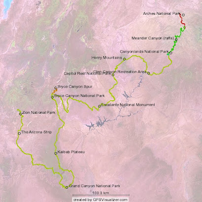
Start: Salt Valley Road NP boundary
End: Willow Springs Trail, western NP boundary
Nightly low: 35 F
Miles: 12.5
After the obligatory photos at the park boundary of two eager trekkers putting on their packs in earnest for the first time, we waved goodbye to Caron’s friend David Morgan who was nice enough to deposit us there. We
 made quite a few physical and gear-related adjustments as we walked the first 7 miles of park road, but the largest adjustment for me was purely mental. I have done the PCT hike and I knew this moment was coming. In essence, it goes like this: having sacrificed like hell to get to this point, walking through a natural area on your own as the ultimate nomad, just what are you supposed to be thinking? There is a tendency to reflect on the magnitude of your preparation and ask “well, so where’s the show?” as if expecting equal, opposite, and immediate recompense for your backlog of effort. Yet, for all the months of dehydrating food, map planning, gear acquisition, food caching, and a generally monotonic disengagement from society, we are left hiking along a lonely windswe
 pt road with no company but a large Swainson’s hawk hunting in the distance. It seems very anti-climatic indeed, and a big problem at this point. But slowly, as the miles drift on and the views begin to stretch out before us, we begin to see that this is exactly why the sacrifice was made-- this is exactly why we are now here.
We stopped to eat lunch, our first official food on the trail, near the end of our road walk and before the first of many sudden and seemingly illogical transitions to cross-country travel. Before doing so, we made mention of the general nature of the back road travelers through Arches. Many were young males in tricked out 4X4 rigs speeding and sliding through the deep sand. I made sure tha
 t when I heard one of these yahoos coming up fast that I got in the middle of the road so as to force them to an immediate stop. Why not remind them that this is a national park? It seems the park service, at least in Arches, has caved into the failed philosophy of “multiple use”, championed by the forest service many decades ago. National forests were parted out to everyone under this idea a distinctly humanistic policy that ignored long-term preservation of the forest and its inhabitants. But national parks, by their own mission statement, are supposed to be different. Allowing use of the back roads by street-legal motorcycles and 4X4’s succeeds in keeping those awful ATVers away, but clearly diminishes the natural history experience and the solitude of the well-intentioned visitor.
We followed a border fenceline from the road down to some sandstone fins where we had to lower down the packs over the lip of a small amphitheater, whose drainage we were now entering. Caron proved herself as an adept rock climber as she descended first and helped me transition down. I think she has much better confidence in her climbing skills than I do. This revelation came at a good time as I sensed she was getting frustrated by my faster hiking pace. The drainage led us out to the western border of the park, where we met a park ranger on a motorcycle. I briefly complained about park vehicle policy in the form of naïve questions and then we slipped over to BLM land to spend the night, exhausted but relieved that we had finally made our start.
Day 2
Monday, April 8
Start: Willow Springs Trail, western NP boundary
End: Dave and Kay’s house, Moab, UT
Nightly low: 48.5 F
Miles: 17.0
We slept nearly 1
 1 hours-- talk about needing some R&R! Caron wasn’t hungry (a very strange deviation) so we decided to continue descending the drainage we left last night until we encountered water. As we were slowly funneled into the ever-developing Courthouse Wash, we began encountering ‘pothole water’, but not of the appetizing variety. We got our first taste of negotiating pouroffs-- sudden and often impassable drops in the wash bottoms. Water erosion, although infrequent as an annual occurrence, over time produces sudden but rounded drops. The pouroffs we encountered weren’t very magnificent and were easy to walk around. But they simply pointed out that walking continuously and unimpeded down these desert canyons is not to be expected. The more challenging pouroffs will come later in the next leg, where the canyons are much deeper and the seasonal water flow is heavier. We even experienced mini “slot canyons” in upper Courthouse Wash. The more magnificent varieties are also ahead of us.
We ate breakfast where the wash merged with Sevenmile Canyon, which has a strong season al (quasi-perennial?) flow. This made a big difference in the nature of the canyon bottom, as dependable water sources attract greedy, space-claiming riparian trees and shrubs. I am not a big fan of hacking my way down riparian desert habitats and I think Caron is also now a member of this non-fan club. With no trail and the need to follow the flow downstream, it rapidly became apparent that the best mode of travel is down the creek itself. It is a simple matter to lose the creek if tracking it from the side. Fighting the brush means not keeping a close eye on the meandering creek and it can be lost in short order. Where did it go and where is it going? “Downstream” is not an apparent concept where the elevational differences of merging side canyons are not readily detectable, especially through thick underbrush. A permanent tr
 ail would not be possible here because after each year of flash flooding, the slate gets wiped clean. At one point, the stream became braided and we followed an
ill-fated channel that ended in a blind drainage. However, beyond thisemerged a well-worn trail above the flow channel that greatly facilitated movement down the wash. We followed this trail another 7 miles out of the canyon to the southern boundary of Arches, all the while losing and rediscovering our friendly trail countless times.
 al (quasi-perennial?) flow. This made a big difference in the nature of the canyon bottom, as dependable water sources attract greedy, space-claiming riparian trees and shrubs. I am not a big fan of hacking my way down riparian desert habitats and I think Caron is also now a member of this non-fan club. With no trail and the need to follow the flow downstream, it rapidly became apparent that the best mode of travel is down the creek itself. It is a simple matter to lose the creek if tracking it from the side. Fighting the brush means not keeping a close eye on the meandering creek and it can be lost in short order. Where did it go and where is it going? “Downstream” is not an apparent concept where the elevational differences of merging side canyons are not readily detectable, especially through thick underbrush. A permanent tr
 ail would not be possible here because after each year of flash flooding, the slate gets wiped clean. At one point, the stream became braided and we followed an
ill-fated channel that ended in a blind drainage. However, beyond thisemerged a well-worn trail above the flow channel that greatly facilitated movement down the wash. We followed this trail another 7 miles out of the canyon to the southern boundary of Arches, all the while losing and rediscovering our friendly trail countless times.
Although we felt like this passage had kicked our butts, we emerged with a sense that we had been initiated, with mercy, to the unique
 tribulations of desert canyon travel. We were rewarded with the pastoral air of a desert creek bottom amid the grandeur of the towering geology overhead. We’ve earned our rite of passage into the next leg: floating the mighty Colorado down Meander Canyon on rafts. We’ll turn over the physical abuse to our upper bodies while hoping our lower halves have time to equilibrate with the upcoming demand.
Hayduke Trail Canyon Count:
1. Courthouse Wash


No comments:
Post a Comment