and "Squaw and Papoose Rock" (pictured in the 'Desert Dog" chapter earlier). We have done a bit of our own photographing and naming of rock formations along the Hayduke Trail. See if you can correctly match the photo labels to the nomenclature listed below. When correctly matched, the letters, read down, will spell a phrase commonly heard across American households these days. Good luck and thank you for playing Rock Match!
Friday, May 8, 2009
Play Rock Match, the exciting online game of skill and chance.
Many prominent landmarks along the Hayduke have official and often creative names that appear on maps. One such famous landmark is known as "The Sewing Machine" (pictured below)  and "Squaw and Papoose Rock" (pictured in the 'Desert Dog" chapter earlier). We have done a bit of our own photographing and naming of rock formations along the Hayduke Trail. See if you can correctly match the photo labels to the nomenclature listed below. When correctly matched, the letters, read down, will spell a phrase commonly heard across American households these days. Good luck and thank you for playing Rock Match!


Friday, May 1, 2009
Desert 'Dog' and Deep Canyons
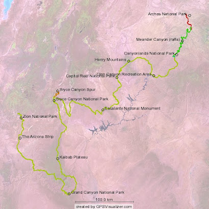
 Now we get back to what this journey is really all about: travelling great distances through deep canyons over great plateaus. We thoroughly enjoyed the respite on the river-- it added a unique twist to the trip. Travelling along with the Grand River for 65 miles provides an excellent foundation for understanding the structural topography of the Hayduke corridor. Being in a sector of the Colorado Plateau, all drainages flow toward and eventually empty into Colorado River. However, we are only periodically crossing the Colorado River (with the obvious exception of the Grand Canyon leg), while weaving in and out of drainage systems. The result is that we will occasionally be travelling down these major drainages and occasionally travelling up them. I'm trying to actually keep track of the number of significant drainage systems that we are traversing (either via the canyon bottom or along a rim or below-rim route) and the direction of travel (up or down). In this rather lengthy and varied section 3, the bookeeping may become a bit challenging.
Day 7
Tuesday, April 14
Start: mouth of Red Lake Canyon, Colorado River, Canyonlands
End: Butler Wash, Needles district, Canyonlands
Miles: 7.3
This morning we quickly found ourselves packed for the trail and ready to hand over our river gear to the Tex's Waterway guides. So I thought I'd try to sneak a quick side trip down to Brown Betty to capture her rage on video. I was stopped 2 minutes later by the drone of a motorboat engine run by a couple of punctual river guides. I'll just have to wait to see Cataract Canyon later-- hopefully in the dubious safety of a raft. Caron handed each guide a $20 tip and they seemed elated to only have to take on two lightweight drybags and be on their way.
We hiked up past Prommel Dome and located the permanent trail that would take us 1200 feet up to the top of lower Red Lake Canyon. Getting reacquainted with the trail in this way was not what we wanted-- especially with a full load of food and 8 liters of water. Heavy packs, steep terrain, and only partially conditioned bodies might equate to misery. At least it would be only temporary and we were somewhat relieved that the sun was concealed behind thick clouds while the air temperature did not seem to be climbing. Still, we did more than break a sweat as we worked our way up the Red Lake Trail and finally reunited with the Hayduke Trail at a point where it took off cross country.
We immediately noticed a set of fairly fresh footprints heading up the off-trail route toward Butler Wash, a long drainage which would contain our route for the next 12 miles or so. Maybe a solo Hayduke hiker was ahead of us.
 We started up Butler from its mouth where it emptied onto a graben (a low-lying flat area in between fault blocks). The going was steep and with quite a few large obstacles as we worked our way toward the upper geological layers of the Canyonlands Needles district. When it appeared that we had finally achieved the upper layer, the wash became significantly less steep and the obstacles seemed to disappear altogether. Unfortunately this is about where the large pour-offs began inserting themselves into our route. We negotiated one such feature by ascending a steep scree slope and routing back into the wash after transcending the impasse. Our exhaustion levels were rising when we encountered the second pour-off. We decided to remain safely on the canyon rim during the course of this 'negotiation' as dusk was quickly approaching along with a distant storm front. At the end of this difficult stretch, it was safe to conclude that our re-entry to the trail was indeed challenging.
Day 8
Wednesday, April 15
Start: Butler Wash, Needles district, Canyonlands
End: divide between Canyonlands and Beef Basin
Miles: 10.4
This morning the weather had definitely taken on a strange and different character. The temperatures were not climbing at all as a rather stiff and persistent wind had whipped up a hazy layer of air-born dust. The clouds were very low to the ground but not really thick with moisture. What moisture was in the air seemed to be mixed with the dust as suggested by the greyish-brown haze. If I was back in California I may have concluded that this was that awful mixture of smoke and fog known as 'smog'. But this wasn't smoke it was dust. This was 'dog'-- cold desert dog to be exact.
At least the walking was easy in the now shallow Butler Wash. Our goal was to find a large rock spire off to the side that would mark the transition to a side drainage and the route out of Canyonlands and into a large adjoining BLM section known as Beef Basin. The wind would occasionally gust and hit us head on, instantly removing any head gear and creating seriously bad hair. At one point, the sky spit out some moisture in the form of large, dust laden droplets which quickly fouled the lenses on our sunglasses. Yes, desert dog is a reality and a first for me. Very bizarre weather conditions indeed.
The day wore on slowly as the wind and cold temperatures seemed to slow progress up the wash. The sun shining through the thin grey clouds cast a yellowish-grey hue about the surrounding rock layers. It looked and felt like a winter storm was descending on the canyon country. Finally, with great relief, the sky opened up with a full snowstorm. The wind died down as we spotted the spire we were looking for just before it vanished in a sea of white snowflakes.
 We made our way up the secondary drainage, through the small natural bridge, known to Haydukers as "Seldom Seen Bridge", and finally out on top of the divide between Canyonlands and Beef Basin. We still needed to get over the divide and down into a drainage containing a natural spring as we were nearly out of water. As I'm sure we will experience many times on this trail, we had travelled nearly two days without access to a natural water source, in this case since leaving the Colorado River, so our water supply was drastically low. However, we did find abundant and fresh pot-hole water on some slickrock formations atop the divide. So we decided to take the next good campsite which happened to be next to some large protective rock formations. It had only stopped snowing for about an hour and we anticipated a night of freezing temperatures and cold, biting wind. To raise our spirits, we built a very hot fire right next to a large reflective rock and thoroughly warmed ourselves before climbing into cold sleeping bags. Another enchanting day was had in the desert wildlands of Utah!
Day 9
Thursday, April 16
Start: divide between Canyonlands and Beef Basin
End: Fable Valley
Miles: 11.9
 We emerged from the tents into a veritable winter wonderland. I'm happy to have now seen Canyonlands after a snowstorm, especially with the sun out and struggling to warm the land. But more distant snowstorms were now drifting our way so we thought it wise to get off
 the divide and down into the basin.
In doing so, the landscape changed dramatically from the colorful layered rock formations of the Needles district to the gently sloping sage and pinon pine flats of Beef Basin. We followed a road for a bit, encountered the remnants of an unfortunate bovine, and entered a wash where we finally encountered the little spring. We eagerly filled up once again with good water.
While following the wash out, we noticed that the cattle trails were accomplishing the same feat but much more efficiently. So we stuck to the bovine route and soon found ourselves at one of the few registers on the Hayduke at the Fable Valley trailhead. The Fable Valley region is one of BLM wilderness study areas. In my opinion, the sheer vastness of the area defines its beauty. With only one or two secondary access roads leading into it, the feeling of remoteness and isolation is similar to any bona fide federal wilderness area.
I read the entries in the trailhead register and was thrilled to learn two things. First, almost every entry for the past six months was made by a Hayduke hiker. There were one or two section hikers ahead, as well as an entry by Dave and Michelle, a thru hiking couple now 25 days ahead of us. But I was also elated to see that "Zoner" was the mysterious solo hiker just ahead of us. Zoner and I both hiked the PCT in 2006 and I had last talked with him in the San Gabriel mountains of southern California that same year. How fitting it would be if after four days of seeing no one else
 in this vast and wild region, I would meet with someone that I know. On the other hand, who else would it be besides another long-distance hiker doing this crazy route?
From here the trail climbed upwards along the rim of the very spectacular Gypsum Canyon. We stopped numerous times to take in the views along the trail and finally made our way onto the rim of the remote Fable Valley. The weather had cleared for most of the afternoon and it looked like we were in for a very pleasant night.
Day 10
Friday, April 17
Start: Fable Valley
End: Young's Canyon pour-off
Miles: 8.6
We awoke to find a layer of wet snow on the roof of the tent and all around Fable Valley for that matter. This delayed our start as we were somewhat reluctant to get out walking in the cold. We waited until the sun made somewhat of a showing and noticed that by this time the snow had completely disappeared.
On the floor of the valley we debated an alternative route that would avoid the hike up a narrow side drainage in order to gain the top of the Dark Canyon Plateau. I'm not fully convinced that it is always necessary to stick to the drainage bottoms to move from bottom to top (or vice versa). Gaining a ridgeline can make the going much more straightforward, provided it can be successfully attained. It is worth considering if the alternative involves bushwhacking up a narrow canyon and negotiating several pour-offs all the way to the top, which was the prescribed route to the Dark Canyon Plateau.
My trusty Zeiss monocular located what appeared to be a manageable break in the cliffs along the ridgeline above the side canyon leading up to the top of the plateau. We decided to commit to get up this crack and onto the ridge. The crux was a little dicier than it looked and did contain some unnerving exposure, but we were able to ascend the route without packs and then dead lift the packs up. The terrain was generally very steep and it was a strenuous ordeal to get up on the plateau. It is unknown to us whether we saved ourselves any strain or aggravation by going along this alternate route since we have never taken the original one. I guess we can at least claim it was 'refreshingly different' than the routine drainage route.
Once on the pinon pine covered plateau, we located the 4WD road that would take us into the entry wash to the formidable Young's Canyon. Along the way we saw a group of very large elk and a herd of mule deer. A large, mean-looking Angus range bull was gaurding the water hole next to the entry way into Young's Canyon. He seemed seriously pissed off that there were no cows at the water hole and quite determined to make our lives the more miserable for it. We skidaddled past him so quickly that I had no time to mention to him that the water hole was dry, thus explaining why cows were largely absent in the vicinity. Sheesh-- domestic animals can be so obtuse at times.We descended quickly into Young's Canyon in anticipation of encountering the notorious impassable pour-off that would send us back up all the way to the rim. We arrived there at the end of the day and began ascending the canyon wall to find the point where the canyon had to be descended once again. At one point I recall being quite awestruck at the increase in the canyon's depth beyond the pour-off. This is indeed an impressive canyon, both in its depth and very steep walls. Tomorrow we might get lucky and make it all the way to the bottom without a major incident.
Day 11
Saturday, April 18
Start: Young's Canyon pour-off
End: Dark Canyon bottom
Miles: 8.0
We began our ascent of the rim of the canyon early in the day and soon located the sandstone tower which serves as a landmark in the route description. The guidebook also refers to a critical "point above the very impressive Young's Canyon" but we were never really sure exactly where this was located. We searched for a route down to the bench containing the sandstone tower but ended up re-routing up and down the steep canyon wall until we found ourselves at the notch between the tower and the south canyon wall. From there it was a steep but relatively safe descent down to the cool flow in the canyon bottom (see Route Commentary below).
Having spent more time on this descent than we had anticipated, we tried making steady progress down the canyon but soon took up walking down the creek to avoid the willow thickets and obstacles. We encountered the first pour-off beyond the steep descent and noticed a well-worn trail ramping up onto a on a bench above the canyon bottom and heading most efficiently toward the confluence of Young's and Dark Canyon, our next objective. The trail was easy to follow and quickly covered the canyon's distance. Shortly before the confluence, the trail made a steep 500 foot descent back to the bottom. This marked the third and final descent into Young's Canyon. Although we remain hopeful that not all upcoming canyon traverses will be quite so replete with impediments, the beauty and wildness of this canyon clearly compensated our efforts to get through it.
At the confluence of Young's Canyon with the larger Dark Canyon, we met up with a party of Outward Bound participants and their two competent group leaders. They had been away from civilization for 50 days and had just completed a raft trip down Cataract Canyon. One of the leaders was very knowledgeable of the Colorado Plateau and most of its major canyons. In fact, he had cairned the route for the final descent into Young's Canyon, for which I thanked him for doing such a thorough job. We briefly talked to a few of the young program participants. They were definitely proud of what they had so far accomplished and wanted to share experiences. However we had to keep the conversation short due to our need to keep moving down canyon. We did about half the mileage we needed to do to exit the canyon before darkness finally enveloped this deep rugged canyon.
Day 12
Sunday, April 19
Start: Dark Canyon bottom
End: near Squaw and Papoose Rock
Today we had a rather pleasant walk out of the majestic Dark Canyon. This area is currently a federally designated Wilderness Study Area. The canyon walls are more than 1000 feet high and the geology is bewildering-- with fossil layers stacked between the more massive sandstone strata. Further down canyon the water volume is surprisingly large, passing in and out of several calm deep pools. With such a strong flow, what would have been only pour-offs in a dry canyon are transformed into cascading waterfalls and graceful slides. Along the way we heard racoons, saw an adult golden eagle and encountered plenty of evidence of larger wildlife.
We finally encountered the base of the Sundance Trail some two miles before Dark Canyon tragically terminates into Lake Powell. This was our route back to higher ground and out of this very deep canyon system. The 'trail' to the top is actually a a very steep obstacle course which climbs up through a wall of broken sandstone cliffs. Besides its 1,200 foot climb, it was no different and certainly no more difficult than any other vertical route we have so far encountered. Once on top the going was considerably easier as the trail gave way to a road and then another cross-country traverse that descended through pinon and sage flats toward a curious rock formation called "Squaw and Papoose Rock". There we spent the night under the watchful eyes of this partial family unit.
Day 13
Monday, April 20
Start: near Squaw and Papoose Rock
End: Hite Marina, Lake Powell
We broke camp early to get a jump on the hot sun and returned to what would be a long day of road walking to Hite Marina on Lake Powell. We were still in the Glen Canyon National Recreation Area which we had entered upon exiting the Dark Canyon WSA. Soon a large canyon came into view and we knew by its size that it contained the Colorado River. This was perhaps the final stretch of Cataract Canyon where the raging river would soon be transformed into the muddy headwaters of that most unnatural feature of the Colorado Plateau known as Lake Powell. From there, we continued our long hot road walk toward Hite Marina, where our first mailed resupply box awaited.
The construction of Glen Canyon dam and the creation of Lake Powell in the 60's polarized budding environmentalists and those that supported creating a vital economic resource and bolstering America's energy independence. The story is well-known and the polarity has maintained itself ever since. There are those of us that are still hoping somehow the dam will outlive its value will have to be safely dismantled. There are those that see it as an invaluable source of recreation and economic stimulation for the related industries such as house-boating, sport fishing, water skiing and heavy drinking. There are those that simply don't care whether there is a large reservoir perched in the middle of the Colorado Plateau, but they don't count in this discussion. No matter what opinions are cast about, there are a few undeniable facts involving geology and climate.
Lake Powell won't last long and I'm not even talking geological time here. First, it is filling up with sediments at an alarming rate. The sediment-laden waters through which we paddled down Meander Canyon emerge at Glen Canyon's spillway as clear and cold. Where'd those sediments go? Secondly, the lake levels have been dropping dramatically in the past 5 years. Discharge from the mountain basins emptying into the Colorado River have diminished significantly. Evaporation is now the most common means for a water molecule to exit Lake Powell. As the cause of this remains debatable, the effects are all too obvious along the waterfront.
Shortly before merging with the paved Hwy 95, we met a very nice couple in a 1-ton Chevy pick-up out photographing and enjoying the countryside. They supplied us with enough water to see us the rest of the way into Hite. We immediately noticed the reduction in the lake levels upon approaching the marina, whose popularity had obviously waned in the recent past because of the lowering. We finally made it to the store with great anticipation for candy, chips, and cold drinks.  Unfortunately the little store had yet to receive a full shipment of the typical convenience store staples, save for ice-cold, 3.2% Corona. So we had a few while talking to Richard and Joanne Chee, store proprietors. After getting our resupply box and new supply of maps, Joanne took us down to the bathrooms and now-defunct fish-cleaning station in order to hang out in the shade and take a "sink shower".We were there for quite some time before the nice lady who we had met out on the road earlier with her husband came up and offered an invitation for dinner down at the Montana 'Fifth Wheel'. We immediately accepted and were on our way down the now unintentionally long 1/4 mile boat ramp to the edge of the starving reservoir.
 Unfortunately the little store had yet to receive a full shipment of the typical convenience store staples, save for ice-cold, 3.2% Corona. So we had a few while talking to Richard and Joanne Chee, store proprietors. After getting our resupply box and new supply of maps, Joanne took us down to the bathrooms and now-defunct fish-cleaning station in order to hang out in the shade and take a "sink shower".We were there for quite some time before the nice lady who we had met out on the road earlier with her husband came up and offered an invitation for dinner down at the Montana 'Fifth Wheel'. We immediately accepted and were on our way down the now unintentionally long 1/4 mile boat ramp to the edge of the starving reservoir.
Bryan and Lynn invited us into their true 'home on the road'. They have given it all up to cruise the sights of the U.S. in an amazingly comfortable and functional Fifth Wheel. They whipped up a delicious chicken dinner with amazing efficiency as we perused Bryan's gallery of breath-taking original photographs he had taken in some of the locations they had visited. We retreated outside for dinner and afterward played with their two dogs, Dodger and Paco, as their little Senegal parrot named YoYo occasionally squawked and whistled from inside the trailer. What an interesting lifestyle these two generous people have adopted! It certainly gave us some common ground in discussing our respective adventures-- after all we were all gypsies, only they were driving and we were walking.
Caron and I decided to camp down next to the trailer and were awakened by Lynn the next morning for yet another gracious offering of sausage, biscuits and gravy. We could not have fared better even with a well-stocked store at the marina. Lynn further offered to take us to the trailhead for the next section of the Hayduke and we decided it would be best to continue on the trail in short order. Save for a couple of new-found good friends, there is not much at Lake Powell these days other than a rapidly retreating shoreline.
Total Hayduke miles: 164
Hayduke canyon count:
Red Lake Canyon (up)
Butler Wash (up)
Seldom Seen Bridge drainage: (up)
Gypsum Canyon (down)
Fable Valley (up)
Young's Canyon (down)
Dark Canyon (down)
Route commentary:
1. We substituted a ridge-based climb for the drainage-based ascent up the side-arm to Fable Valley in order to top the Dark Canyon Plateau. We don't know what we really missed there and so can't comment on the actual utility of this alternative route. The climb up the crux was exposed and the remaining ascent was very strenuous so the whole thing bordered on being a questionable move.
2. The issue of how to re-descend Young's Canyon is an important topic for Hayduke hikers. Having now done this section, I hope the following will help clear up what we thought was a fairly confusing route description that could potentially lead to an imperiled attempt at using it.The goal is to get to the base of the sandstone tower at the prominent notch between it and the canyon wall after safely ascending to the rim from the pour-off. A straightforward way to do this is to walk southwest along the rim until the tower and its bench are in full view and bearing 245 degrees (true North). There are several ways to descend safely to the bench from there. I don't know if this is "the point" as described in the book, but the description makes more sense if it is. From the notch, just plop over the north edge and be safe on the steep, well-cairned descent route. For those who prefer the least amount of confusion in finding landmarks (GPS), the coordinates for the notch are: UTM 12 S 0583527, 4190874
Saturday, April 25, 2009
Life is Grand
We now embark on our float down Meander Canyon on the mighty Colorado River (in past times known as "The Grand River"). This leg stretches from Moab to Spanish Bottom, a total of 65 river miles. The last 31 miles will be within Canyonlands NP. Our mode of travel will be in 'packrafts', small one-person inflatables designed to carry a hefty drybag on the bow. Whether this will be comfortable, or even feasible for such a distance, is still unknown and this has been nagging at the back of my mind for quite some time.
 Toward the end of the day, the sounds of jeep engines, low flying aircraft, and industrial machinery had all but vanished. Finally these little rafts were drifting quietly between huge canyon walls where the curious call of the canyon wren was now the most audible feature. We pulled up on a sandbar island close to the NP boundary and managed to set the tent in a patch of willow trees on the island's interior. Solitude was finally at hand.
Day 5
Sunday, April 12
Start: Colorado River, Canyonlands NP boundary
End: Colorado River, near The Loop, Canyonlands NP
River miles: 21.0
We bid our final farewells to the eclectic little town of Moab, Utah, which has been our home base of sorts for the past week. We stayed in the house of Dave and Kay McLean, who graciously offered their house to us even while they were away on their own adventure. Having a warm home, with its odd but interesting collection of VHS movies and excellent natural history books, kept our spirits up for the journey ahead.
Jeep Week was in full swing in Moab this week. I have no idea how this extravaganza/fiasco evolved into what it currently is today, but it surely deserves a comment here. As a boy growing up in Durango, I remember exploring the high roads above Silverton in my dad's trusty Scout (the early International Harvester variety). Flesh-colored and monotoned with absolutely no extras or options (even lacking that necessary gear ratio for a comfortable highway drive), this vehicle was the most humble of servants. And that's exactly what it was-- a vehicle to explore the timberline country of southwestern Colorado. In fact, the only modification ever performed on it was the extraction of the back seats and the installation of an unsightly green bench seat bolted to a large plywood base. This was performed to accomodate the need for extra seating when my younger brother became old enough to go jeeping. My dad, a transplant from Decatur, Illinois, was far more interested in "going up to the high country" as he put it, than engaging in any sort of this machine-worshipping nonsense one sees out here in Moab these days. Armed with a simple rangefinder Petri 35 mm and humble Scout, we all explored and photographed the old ghost towns and high passes of the San Juan mountains long before the letters ATV were ever strung together.
Don't get me wrong here, I'm not completely anti-4X4. I respect the old Land Rovers, Toyota Land Cruisers, and especially the Willy's jeep pick-ups. Beautiful machines in their own right. But I have no reservations about bitching at the mob-mentality of Jeep Week in Moab. At the ever-popular Moab Diner, the t-shirt of one super-charged jeep freak read "Life begins where the pavement ends". Given that we modified our trip to replace the Lockhart Basin hike with a packraft float into Canyonlands, initially to avoid the motorized parade of metalized manhood extensions, my inner t-shirt read "Life begins where YOUR jeep road ends", that being the G-rated version.
Day 3
Friday, April 10
Start: Colorado River, The Portal
End: Colorado River, near Potash
River miles: 9.0 We finally hit the river today after yet another episode of scrambling and rearranging gear. It dawned on us earlier in the day that this was our final opportunity to decide which gear was to proceed with us for the remaining 800+ miles of the trip. So it seemed the decisions were more crucial than before and this didn't help with the stress levels. Adding to this was the potentially disastrous outcome that this packraft idea was doomed to failure from the start. Would these tiny little floatables buckle under the 50 lb. weight of the drybags plus our own bodyweight? The moment of truth was very close now.
We put in near The Portal, that rather spectacular gap in a huge cliff face through which the Colorado River lazily feeds itself into the canyon country beyond. After taking some time to inflate the rafts and the air matress floors, we packed the drybags, carefully sealed them, and lashed them to bow. Nervously squeezing into the rafts and sealing up the spray skirts, we finally launched these tiny crafts into the chilly, muddy waterway to Canyonlands. To our great relief, the rafts seemed perfectly content to float high on the current. They were maneuverable and even a bit on the comfortable side.
Stress relief! Now we just hoped the weather would clear up for the long paddling miles ahead. Still, even the cloudy and windy conditions didn't dampen our spirits as we floated past "Wall Street", where we counted six different climbing parties ascending various cracks up the famed monolith. The road on the left side of the river eventually peeled inland so only the parade of heavy trucks to the Potash salt mining plant remained on our right. Maybe we will finally shed the last of the motorized distractions tomorrow. We eventually pulled the boats out on a sand bar across the river from the roadway. Although an occasional loud truck would blare by in the night, the anticipation of our second day of 'packrafting' kept things on the up and up.
Day 4
Saturday, April 11
Start: Colorado River, near Potash
End: Colorado River, Canyonlands NP boundary
River miles: 19.0
Sand, sand, sand! It looks inviting and soothing on a post card, and so it does floating past the numerous sandbars on the Colorado River, but if you camp on it, it begins to insert itself into every aspect of your daily life. Small price to pay, really. This was just too cool to wake up on the river on our own private sandbar and ready our transports for another mellow day of floating and paddling south into Canyonlands.
 It didn't actually turn out to be so mellow. Shortly into our paddle, the sky became ominous as a thundershower crept its way up the river. All we could do was photograph the calamity as it approached, and when it did hit us, it hit hard. The rain covered the lenses to my glasses and I was half-blinded as I tried to steady the boat to run parallel to the current. Wind-whipped waves struck the boat broadside and reminded me just how laterally unstable are these little crafts. I began to gather just how unfortunate it would be if one or both of us were to flip in the cold deep muddy waters of the Colorado. But, as fast as it had descended, the storm moved out and was quickly replaced with sun, warmth, calm waters, and Caron's claim that she was enoying every minute of the tempest.
We pulled out at the Potash boat launch to use the last available toilet facility. This would also mark the last of the motorized vehicles running alongside the river. We noticed a park ranger had pulled up to use the restroom so we decided to ask him if he could authorize an extension of our permit for Canyonlands, given that we were a bit behind in our schedule. It turned out he was a Utah state trooper but he did not let that stop him from blindly advising us on our 'permit problem'.
Leaving the Potash launch, we were finally beginning to feel emancipated from the sounds of the motorized world when we noticed an occasional drone of raging engines in the distance. This would be Jeep Week, of course. Many of the off-road routes run next to the river. How greatly demoralizing this was. How long was this going to take anyway? About that time, a low-flying helicopter came in from the west and then decided to circle us again even lower for a better look. "Hmmm.... must be those OTHER individuals on yellow packrafts floating down the Colorado River in clear violation of their permits whose dates don't match the locations that we're looking for". So they flew away. As soon as they had departed, we noticed the sound of power tools humming along in some sort of housing structure off to our right. Well, damn, we weren't in Canyonlands yet and still on BLM land so I guess this was allowed. Something we didn't really expect however.
 Toward the end of the day, the sounds of jeep engines, low flying aircraft, and industrial machinery had all but vanished. Finally these little rafts were drifting quietly between huge canyon walls where the curious call of the canyon wren was now the most audible feature. We pulled up on a sandbar island close to the NP boundary and managed to set the tent in a patch of willow trees on the island's interior. Solitude was finally at hand.
Day 5
Sunday, April 12
Start: Colorado River, Canyonlands NP boundary
End: Colorado River, near The Loop, Canyonlands NP
River miles: 21.0
Today was a superlative day on the river. Everything seemed exactly right and just what one would hope for on a trip like this. Upon our departure from the island, a great-blue heron glided gracefully onto it as if it had been forever waiting for the pesky humans to vacate. The sun was in full shine amid signs of stable weather as we finally passed into Canyonlands. With new and staggering geological formations around every bend in the river, we moved downriver with increasing anticipation.
We saw three great blue herons altogether, an osprey, avocets, and eventually became quite amused by the antics of the Canadian geese which are quite numerous along the sandbars here. We watched as one gander challenged another for ownership of the sandbar. My educated guess is that the gander who maintains quality river territory, perhaps measured by security from nest predation, will get the highest number of interested females. One challenge escalated to the cliffs on the side of the river opposite to the territory in contention. There it played out as a ritualized escalation of physical confrontation until one gander finally flew away in retreat with an astounding vocal lashing by the winner. The echoes down canyon made it seem like more than one goose was doing the scolding. Most amusing indeed!
Progress in terms of mileage is better than one would expect in these little rafts. I've been running my gps all day and taking note of the speed, total distance, total time stopped, and average speed while moving. There is no whitewater so far on this stretch and only occasionally is there a swift current. Depending on the location on the river (e.g. an inside or outside bend), the existence of submerged sandbars, and the general width of the river channel, pure drift alone will yield 1.5 to 2.2 mph. Paddling constantly will increase this to 4.0 mph. Since we are paddling intermitently, but being consistent about it, we are achieving a moving average of about 3.2 mph. This is better than one can do hiking this canyon, where moving averages are typically 2.8 or lower. The difference comes from the fact that we are still moving when resting (i.e. not paddling). I think I like this packrafting concept!
 Across from Lathrop canyon, we pulled up on a tamarisk-lined beach for lunch. Momentarily leaving the river corridor, we visited some ancient native ruins in the cliffs high above the river bottom. Displayed prominently on the sandstone were the outlined hands of the family that had lived there. It's easy to conclude how peaceful their life must have been. On the other hand, this was a life without food markets, convenience stores, packrafts, antibiotics, and red rock vacations. Life surely was different for the ancients. I still like to think they occasionally looked around and felt satisfied about their location.
Tomorrow will be the end of our little river adventure. We will hand over the drybags to one of the Moab-based river tour companies at Spanish Bottom. The gear will work its way back to Moab on one of the motor boats that plow up and down the river once or twice a day. Although this commercial enterprise is a bit disruptive of the quiet solitude we are now getting on the river, we are going to use it to lighten our load significantly. Plus, when the boats come through, they generate a 5-minute interlude of class 1 rapids that are quite fun to play around in before the river returns to its slow meandering ways.
 We stopped to set up camp on yet another 'private' sandbar only 16 miles from where we would resume our foot-based travel through Canyonlands.
Day 6
Monday, April 13
Start: Colorado River, near The Loop, Canyonlands NP
End: Colorado River, mouth of Red Lake Canyon, Canyonlands NP.
River miles: 16.0
After an early breakfast of grits with sausage and cheese, we readied the rafts for the final day on the river. By now we were getting fairly adept at fixing the dry bags onto the rafts. We first lay the empty backpacks flat onto the bow, plop the dry bags loaded with all other provisions on top and lash this to the raft's grab loops. A smaller drybag containing camera gear, a water bladder, gloves, sunscreen, and related items is then secured to the main drybag lashings. Finally, my gps goes into a small plastic dry bag with a see-through window to keep track of the speed and distance travelled. It's all a very compact arrangement and squeezing into the raft often proves a bit challenging. However, once we manage to get the spray skirt velcroed shut, we begin to feel self-contained and very mobile.
The best time is made by paddling the crafts close to the inside banks, which also increases the likelihood of seeing animals up close. Shortly into the day, we entered a section of river called "The Loop", whose 5-mile section of double hairpin loops yields only a single mile of downstream progress. Thereafter we re-entered the Meander Anticline where the course of the river follows the apex of strongly upwarped sediments. The upwarping was thought to be caused by vast and deep deposits of salt, forced into a plastic phase and squeezed upward by the overbearing weight of thick sandstone deposits on top. I find it very soothing in a way that these amazingly intense physical forces, occurring deep beneath the earth's surface hundreds of millions of years ago, would later determine the course of this great river. Having this understanding and, at the same time, looking up through thousands of feet of compressed sediments, provides one with a tangible link to the geologic past. Linking time and space is one of the great triumphs of science. Of the many animal life forms roaming the earth at this time, one was ancestral to humans who would eventually figure all of this out! It's indeed exciting to be a product of this great earth.
Further downstream we encountered the only set of rapids on this stretch of river, created when a massive chunk of canyon wall slid into the river and narrowed its channel. Although the rapids were only of the very manageable 'class 2' variety, they made quite a racket from a good distance upstream. Nonetheless, I never felt cheated by the absence of more technical whitewater as I was too interested in completing this raft trip without a major incident. Shortly after negotiating 'The Slide', we found ourselves at the famous confluence of the Green and Colorado Rivers. A huge sandbar lay beneath only a few feet of water just beyond the point where the Green yields its huge volume to the Colorado. We thought of the unique photo opportunities by standing up in the middle of these two great western rivers, but decided it would only look cool from the confluence overlook more than a thousand feet overhead.
We finally made it to Spanish Bottom, a wide canyon area created by the dissolution and removal of an ancient buried salt dome. We could see our take-out point-- the Prommel Dome, a massive gypsum plug associated with deeply buried evaporite deposits. This marked the end of our four days on the river. Continuing from here on the packrafts would be suicidal as Cataract Canyon, known for its hazardous drops and thoroughly challenging whitewater, lay just beyond the take-out.
We felt refreshed and ready to return to a leg-powered exploration of the canyons high above and distant from the Colorado. We deflated our little rafts, cleaned them the best we could, and packed them away into the dry bags. After a quick dinner, we dozed off to the distant roar of Brown Betty, the first big drop of the mighty Grand in Cataract Canyon.
Total Hayduke miles: 95
Hayduke canyon count for this section:
Meander Canyon
Sent via BlackBerry by AT&T
Thursday, April 9, 2009
Arches: desert hiking initiation
I am here back in Moab after arriving 4 days earlier, still uneasy and nerve-shattered from the great escape from southern California. Since then, we walked our first leg of the Hayduke, a 30-mile trek from the northern boundary of Arches NP to its southern boundary on a highway just outside of Moab, and finally through town to stay at Dave and Kay’s house (Caron has some great friends in this little corner!).
Day 1
Sunday, April 7
Start: Salt Valley Road NP boundary
End: Willow Springs Trail, western NP boundary
Nightly low: 35 F
Miles: 12.5
After the obligatory photos at the park boundary of two eager trekkers putting on their packs in earnest for the first time, we waved goodbye to Caron’s friend David Morgan who was nice enough to deposit us there. We made quite a few physical and gear-related adjustments as we walked the first 7 miles of park road, but the largest adjustment for me was purely mental. I have done the PCT hike and I knew this moment was coming. In essence, it goes like this: having sacrificed like hell to get to this point, walking through a natural area on your own as the ultimate nomad, just what are you supposed to be thinking? There is a tendency to reflect on the magnitude of your preparation and ask “well, so where’s the show?” as if expecting equal, opposite, and immediate recompense for your backlog of effort. Yet, for all the months of dehydrating food, map planning, gear acquisition, food caching, and a generally monotonic disengagement from society, we are left hiking along a lonely windswe
 pt road with no company but a large Swainson’s hawk hunting in the distance. It seems very anti-climatic indeed, and a big problem at this point. But slowly, as the miles drift on and the views begin to stretch out before us, we begin to see that this is exactly why the sacrifice was made-- this is exactly why we are now here.
We stopped to eat lunch, our first official food on the trail, near the end of our road walk and before the first of many sudden and seemingly illogical transitions to cross-country travel. Before doing so, we made mention of the general nature of the back road travelers through Arches. Many were young males in tricked out 4X4 rigs speeding and sliding through the deep sand. I made sure tha t when I heard one of these yahoos coming up fast that I got in the middle of the road so as to force them to an immediate stop. Why not remind them that this is a national park? It seems the park service, at least in Arches, has caved into the failed philosophy of “multiple use”, championed by the forest service many decades ago. National forests were parted out to everyone under this idea a distinctly humanistic policy that ignored long-term preservation of the forest and its inhabitants. But national parks, by their own mission statement, are supposed to be different. Allowing use of the back roads by street-legal motorcycles and 4X4’s succeeds in keeping those awful ATVers away, but clearly diminishes the natural history experience and the solitude of the well-intentioned visitor.
We followed a border fenceline from the road down to some sandstone fins where we had to lower down the packs over the lip of a small amphitheater, whose drainage we were now entering. Caron proved herself as an adept rock climber as she descended first and helped me transition down. I think she has much better confidence in her climbing skills than I do. This revelation came at a good time as I sensed she was getting frustrated by my faster hiking pace. The drainage led us out to the western border of the park, where we met a park ranger on a motorcycle. I briefly complained about park vehicle policy in the form of naïve questions and then we slipped over to BLM land to spend the night, exhausted but relieved that we had finally made our start.
Day 2
Monday, April 8
Start: Willow Springs Trail, western NP boundary
End: Dave and Kay’s house, Moab, UT
Nightly low: 48.5 F
Miles: 17.0
We slept nearly 1 1 hours-- talk about needing some R&R! Caron wasn’t hungry (a very strange deviation) so we decided to continue descending the drainage we left last night until we encountered water. As we were slowly funneled into the ever-developing Courthouse Wash, we began encountering ‘pothole water’, but not of the appetizing variety. We got our first taste of negotiating pouroffs-- sudden and often impassable drops in the wash bottoms. Water erosion, although infrequent as an annual occurrence, over time produces sudden but rounded drops. The pouroffs we encountered weren’t very magnificent and were easy to walk around. But they simply pointed out that walking continuously and unimpeded down these desert canyons is not to be expected. The more challenging pouroffs will come later in the next leg, where the canyons are much deeper and the seasonal water flow is heavier. We even experienced mini “slot canyons” in upper Courthouse Wash. The more magnificent varieties are also ahead of us.
Although we felt like this passage had kicked our butts, we emerged with a sense that we had been initiated, with mercy, to the unique tribulations of desert canyon travel. We were rewarded with the pastoral air of a desert creek bottom amid the grandeur of the towering geology overhead. We’ve earned our rite of passage into the next leg: floating the mighty Colorado down Meander Canyon on rafts. We’ll turn over the physical abuse to our upper bodies while hoping our lower halves have time to equilibrate with the upcoming demand.
Hayduke Trail Canyon Count:
1. Courthouse Wash
Day 1
Sunday, April 7
Start: Salt Valley Road NP boundary
End: Willow Springs Trail, western NP boundary
Nightly low: 35 F
Miles: 12.5
After the obligatory photos at the park boundary of two eager trekkers putting on their packs in earnest for the first time, we waved goodbye to Caron’s friend David Morgan who was nice enough to deposit us there. We
 made quite a few physical and gear-related adjustments as we walked the first 7 miles of park road, but the largest adjustment for me was purely mental. I have done the PCT hike and I knew this moment was coming. In essence, it goes like this: having sacrificed like hell to get to this point, walking through a natural area on your own as the ultimate nomad, just what are you supposed to be thinking? There is a tendency to reflect on the magnitude of your preparation and ask “well, so where’s the show?” as if expecting equal, opposite, and immediate recompense for your backlog of effort. Yet, for all the months of dehydrating food, map planning, gear acquisition, food caching, and a generally monotonic disengagement from society, we are left hiking along a lonely windswe
 pt road with no company but a large Swainson’s hawk hunting in the distance. It seems very anti-climatic indeed, and a big problem at this point. But slowly, as the miles drift on and the views begin to stretch out before us, we begin to see that this is exactly why the sacrifice was made-- this is exactly why we are now here.
We stopped to eat lunch, our first official food on the trail, near the end of our road walk and before the first of many sudden and seemingly illogical transitions to cross-country travel. Before doing so, we made mention of the general nature of the back road travelers through Arches. Many were young males in tricked out 4X4 rigs speeding and sliding through the deep sand. I made sure tha
 t when I heard one of these yahoos coming up fast that I got in the middle of the road so as to force them to an immediate stop. Why not remind them that this is a national park? It seems the park service, at least in Arches, has caved into the failed philosophy of “multiple use”, championed by the forest service many decades ago. National forests were parted out to everyone under this idea a distinctly humanistic policy that ignored long-term preservation of the forest and its inhabitants. But national parks, by their own mission statement, are supposed to be different. Allowing use of the back roads by street-legal motorcycles and 4X4’s succeeds in keeping those awful ATVers away, but clearly diminishes the natural history experience and the solitude of the well-intentioned visitor.
We followed a border fenceline from the road down to some sandstone fins where we had to lower down the packs over the lip of a small amphitheater, whose drainage we were now entering. Caron proved herself as an adept rock climber as she descended first and helped me transition down. I think she has much better confidence in her climbing skills than I do. This revelation came at a good time as I sensed she was getting frustrated by my faster hiking pace. The drainage led us out to the western border of the park, where we met a park ranger on a motorcycle. I briefly complained about park vehicle policy in the form of naïve questions and then we slipped over to BLM land to spend the night, exhausted but relieved that we had finally made our start.
Day 2
Monday, April 8
Start: Willow Springs Trail, western NP boundary
End: Dave and Kay’s house, Moab, UT
Nightly low: 48.5 F
Miles: 17.0
We slept nearly 1
 1 hours-- talk about needing some R&R! Caron wasn’t hungry (a very strange deviation) so we decided to continue descending the drainage we left last night until we encountered water. As we were slowly funneled into the ever-developing Courthouse Wash, we began encountering ‘pothole water’, but not of the appetizing variety. We got our first taste of negotiating pouroffs-- sudden and often impassable drops in the wash bottoms. Water erosion, although infrequent as an annual occurrence, over time produces sudden but rounded drops. The pouroffs we encountered weren’t very magnificent and were easy to walk around. But they simply pointed out that walking continuously and unimpeded down these desert canyons is not to be expected. The more challenging pouroffs will come later in the next leg, where the canyons are much deeper and the seasonal water flow is heavier. We even experienced mini “slot canyons” in upper Courthouse Wash. The more magnificent varieties are also ahead of us.
We ate breakfast where the wash merged with Sevenmile Canyon, which has a strong season al (quasi-perennial?) flow. This made a big difference in the nature of the canyon bottom, as dependable water sources attract greedy, space-claiming riparian trees and shrubs. I am not a big fan of hacking my way down riparian desert habitats and I think Caron is also now a member of this non-fan club. With no trail and the need to follow the flow downstream, it rapidly became apparent that the best mode of travel is down the creek itself. It is a simple matter to lose the creek if tracking it from the side. Fighting the brush means not keeping a close eye on the meandering creek and it can be lost in short order. Where did it go and where is it going? “Downstream” is not an apparent concept where the elevational differences of merging side canyons are not readily detectable, especially through thick underbrush. A permanent tr
 ail would not be possible here because after each year of flash flooding, the slate gets wiped clean. At one point, the stream became braided and we followed an
ill-fated channel that ended in a blind drainage. However, beyond thisemerged a well-worn trail above the flow channel that greatly facilitated movement down the wash. We followed this trail another 7 miles out of the canyon to the southern boundary of Arches, all the while losing and rediscovering our friendly trail countless times.
 al (quasi-perennial?) flow. This made a big difference in the nature of the canyon bottom, as dependable water sources attract greedy, space-claiming riparian trees and shrubs. I am not a big fan of hacking my way down riparian desert habitats and I think Caron is also now a member of this non-fan club. With no trail and the need to follow the flow downstream, it rapidly became apparent that the best mode of travel is down the creek itself. It is a simple matter to lose the creek if tracking it from the side. Fighting the brush means not keeping a close eye on the meandering creek and it can be lost in short order. Where did it go and where is it going? “Downstream” is not an apparent concept where the elevational differences of merging side canyons are not readily detectable, especially through thick underbrush. A permanent tr
 ail would not be possible here because after each year of flash flooding, the slate gets wiped clean. At one point, the stream became braided and we followed an
ill-fated channel that ended in a blind drainage. However, beyond thisemerged a well-worn trail above the flow channel that greatly facilitated movement down the wash. We followed this trail another 7 miles out of the canyon to the southern boundary of Arches, all the while losing and rediscovering our friendly trail countless times.
Although we felt like this passage had kicked our butts, we emerged with a sense that we had been initiated, with mercy, to the unique
tribulations of desert canyon travel. We were rewarded with the pastoral air of a desert creek bottom amid the grandeur of the towering geology overhead. We’ve earned our rite of passage into the next leg: floating the mighty Colorado down Meander Canyon on rafts. We’ll turn over the physical abuse to our upper bodies while hoping our lower halves have time to equilibrate with the upcoming demand.Hayduke Trail Canyon Count:
1. Courthouse Wash
Preparation H (H for Hayduke, that is)
Escaping from the confines of society to embark on something as grand as the Hayduke Trail requires an overwhelming amount of concentration. Ironically, in order to effect one’s escape, those aspects of society that proved so intensely mundane and which, in part, motivated the escape in the first place, must be now considered top priority. Pay this bill, pay that person, set up payments for future bills, clean the damn house (the whole damn house!). In short, you must prepare for continuing membership in society even while in absentia. This is just one of the contradictions that we face when we aren’t really escaping for that long. We could just say “screw the entire thing”, but something tells me this wouldn’t produce the best outcome. We will be tethered in many ways on this hike. As we walk through canyon after canyon in blissful desolation, we are also walking a line of balance between temporary isolation and return to a permanent society. This optimum was beautifully elucidated by the story, Into The Wild. You should take in this movie or read the book if you haven't had the chance.
Add to this confusing set of obligations the enormity of preparing for a 75-day hike through North America’s wildest canyon country, and you have the makings of a very stressful episode. In addition to the monotony and sheer exasperation of cleaning and moving both our apartments, we were pressed to get the resupply boxes packed and scheduled for shipment-- the dates for the national park permits being the main moderator here. In the end it took 36 hours longer than planned to accomplish this. We considered taking the first section through Arches NP out of the picture but this did not sit well from a philosophical perspective. Also, I figured that this trek through Arches, being described as one of the easier stretches of the Hayduke, would serve as an important initiation into hiking and navigating this terrain. And let’s not forget that we are really here to experience the beauty of the area not from the usual tourist’s vantage point.
We ended up attending a 50-year birthday party for a good friend in Vista, and staying an additional 2 days at his house. The occasion was merely a good excuse for a reunion of sorts among the Ocean Beach crowd from 25+ years ago. Ironically, I was resistant from the start to attend the nostalgia party because of the ostensible intransigence of our trail schedule. Add a dash of reality and we’re there for the weekend. It was great to see everyone-- the reminiscing, drinking, and playing of bluegrass was a much better way to initiate our escape from society.
Add to this confusing set of obligations the enormity of preparing for a 75-day hike through North America’s wildest canyon country, and you have the makings of a very stressful episode. In addition to the monotony and sheer exasperation of cleaning and moving both our apartments, we
 were pressed to get the resupply boxes packed and scheduled for shipment-- the dates for the national park permits being the main moderator here. In the end it took 36 hours longer than planned to accomplish this. We considered taking the first section through Arches NP out of the picture but this did not sit well from a philosophical perspective. Also, I figured that this trek through Arches, being described as one of the easier stretches of the Hayduke, would serve as an important initiation into hiking and navigating this terrain. And let’s not forget that we are really here to experience the beauty of the area not from the usual tourist’s vantage point.
We ended up attending a 50-year birthday party for a good friend in Vista, and staying an additional 2 days at his house. The occasion was merely a good excuse for a reunion of sorts among the Ocean Beach crowd from 25+ years ago. Ironically, I was resistant from the start to attend the nostalgia party because of the ostensible intransigence of our trail schedule. Add a dash of reality and we’re there for the weekend. It was great to see everyone-- the reminiscing, drinking, and playing of bluegrass was a much better way to initiate our escape from society.
Saturday, March 21, 2009
Cache cab adventures.

Yes, just a few snafus to be sure. We cached food, and supplies in two locations-- the first in the Burr Trail area of Capitol Reef National Park (see photo, Henry Mountains in background) and the second near the Arizona Strip segment of the hike.
In the latter case, it was disquieting to watch the interment ceremonies as the sun was beginning to set, not knowing what type of shape we would be in when we found ourselves once again very concerned with locating this tiny, nondescript patch of soil so stealthily concealed in the middle of nowhere. Our survival across the strip, while not garaunteed, would be greatly enhanced after digging up the contents of this cache. Relying on a food cache is not something I have done on a long hike. I definitely prefer the certainty factor of a mail-in resupply, owing to the obvious contingency of shopping for food should something happen to the resupply box. To heighten the anxiety, the the oft-cited problem with a blind dependence on technology did manage to rear its ugly head: the batteries on my GPS completely died before the coordinates could be saved. Fortunately, in an age of highly competitive technologies, we found the necessary redundancy in my Blackberry, whose GPS function I never really felt like I would use. But I gladly did then. After photographing the area and promising to remember this skyline, that tree, and that "rock over there", we left with a certain unease which was quickly supplanted by the good feelings of having made some progress toward our ultimate departure. Probably good that we didn't bury that tequila-- getting to Zion from the canyon rim via the Arizona Strip will not be too forgiving of a confused state of mind!
Friday, March 20, 2009
Cachin' In

We will resupply in towns most of the time, but could not find any way around caching in a couple of places. So last weekend we drove to points northeast and buried the necessary food/maps/water. Thanks, George, for your help and support -- we couldn't have done it without you! The trip was fun, not without snafus, but gave us a taste of the adventure in our near future.
We found an excellent place in Escalante, very hiker friendly. They have delicious pizza (made-by-hand dough definitely worth the wait), serve beer and wine, are an outfitter and have campsites (with GREAT bathroom/shower facilities) at very reasonable rates. Please be sure to stop by Escalante Outfitters if you are in the area, and tell them that Whiptail and Caron sent you. It is certainly the place we will revisit when we hitch into Escalante at the end of April.
Are we on schedule? Well, we still have to make some breakfasts, but after that is completed, we'll be ready to put together the resupply boxes that will be sent to us by my friend, Loie (thanks for your help, Lo!!). We're finalizing our pack contents; now my base weight is 17 lbs. With only two weeks left, we are feeling a little pressured, but at the same time are ready to just get out there!
I hadn't been in those beautiful red rocks since the end of last April. Driving through Utah again, I was filled with awe and gratitude knowing that the next time I see that scenery, it'll be up close and personal . . . not in a car, but on foot, close to the earth, out there . . .the way it should experienced. I am so lucky to be able to do this, especially with an experienced thru-hiker like Whiptail.
Stay tuned; we'll be updating more frequently now. Here's to the hike!
We found an excellent place in Escalante, very hiker friendly. They have delicious pizza (made-by-hand dough definitely worth the wait), serve beer and wine, are an outfitter and have campsites (with GREAT bathroom/shower facilities) at very reasonable rates. Please be sure to stop by Escalante Outfitters if you are in the area, and tell them that Whiptail and Caron sent you. It is certainly the place we will revisit when we hitch into Escalante at the end of April.
Are we on schedule? Well, we still have to make some breakfasts, but after that is completed, we'll be ready to put together the resupply boxes that will be sent to us by my friend, Loie (thanks for your help, Lo!!). We're finalizing our pack contents; now my base weight is 17 lbs. With only two weeks left, we are feeling a little pressured, but at the same time are ready to just get out there!
I hadn't been in those beautiful red rocks since the end of last April. Driving through Utah again, I was filled with awe and gratitude knowing that the next time I see that scenery, it'll be up close and personal . . . not in a car, but on foot, close to the earth, out there . . .the way it should experienced. I am so lucky to be able to do this, especially with an experienced thru-hiker like Whiptail.
Stay tuned; we'll be updating more frequently now. Here's to the hike!
Subscribe to:
Posts (Atom)