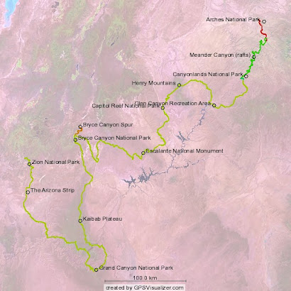
 Now we get back to what this journey is really all about: travelling great distances through deep canyons over great plateaus. We thoroughly enjoyed the respite on the river-- it added a unique twist to the trip. Travelling along with the Grand River for 65 miles provides an excellent foundation for understanding the structural topography of the Hayduke corridor. Being in a sector of the Colorado Plateau, all drainages flow toward and eventually empty into Colorado River. However, we are only periodically crossing the Colorado River (with the obvious exception of the Grand Canyon leg), while weaving in and out of drainage systems. The result is that we will occasionally be travelling down these major drainages and occasionally travelling up them. I'm trying to actually keep track of the number of significant drainage systems that we are traversing (either via the canyon bottom or along a rim or below-rim route) and the direction of travel (up or down). In this rather lengthy and varied section 3, the bookeeping may become a bit challenging.
Day 7
Tuesday, April 14
Start: mouth of Red Lake Canyon, Colorado River, Canyonlands
End: Butler Wash, Needles district, Canyonlands
Miles: 7.3
This morning we quickly found ourselves packed for the trail and ready to hand over our river gear to the Tex's Waterway guides. So I thought I'd try to sneak a quick side trip down to Brown Betty to capture her rage on video. I was stopped 2 minutes later by the drone of a motorboat engine run by a couple of punctual river guides. I'll just have to wait to see Cataract Canyon later-- hopefully in the dubious safety of a raft. Caron handed each guide a $20 tip and they seemed elated to only have to take on two lightweight drybags and be on their way.
We hiked up past Prommel Dome and located the permanent trail that would take us 1200 feet up to the top of lower Red Lake Canyon. Getting reacquainted with the trail in this way was not what we wanted-- especially with a full load of food and 8 liters of water. Heavy packs, steep terrain, and only partially conditioned bodies might equate to misery. At least it would be only temporary and we were somewhat relieved that the sun was concealed behind thick clouds while the air temperature did not seem to be climbing. Still, we did more than break a sweat as we worked our way up the Red Lake Trail and finally reunited with the Hayduke Trail at a point where it took off cross country.
We immediately noticed a set of fairly fresh footprints heading up the off-trail route toward Butler Wash, a long drainage which would contain our route for the next 12 miles or so. Maybe a solo Hayduke hiker was ahead of us.
 We started up Butler from its mouth where it emptied onto a graben (a low-lying flat area in between fault blocks). The going was steep and with quite a few large obstacles as we worked our way toward the upper geological layers of the Canyonlands Needles district. When it appeared that we had finally achieved the upper layer, the wash became significantly less steep and the obstacles seemed to disappear altogether. Unfortunately this is about where the large pour-offs began inserting themselves into our route. We negotiated one such feature by ascending a steep scree slope and routing back into the wash after transcending the impasse. Our exhaustion levels were rising when we encountered the second pour-off. We decided to remain safely on the canyon rim during the course of this 'negotiation' as dusk was quickly approaching along with a distant storm front. At the end of this difficult stretch, it was safe to conclude that our re-entry to the trail was indeed challenging.
Day 8
Wednesday, April 15
Start: Butler Wash, Needles district, Canyonlands
End: divide between Canyonlands and Beef Basin
Miles: 10.4
This morning the weather had definitely taken on a strange and different character. The temperatures were not climbing at all as a rather stiff and persistent wind had whipped up a hazy layer of air-born dust. The clouds were very low to the ground but not really thick with moisture. What moisture was in the air seemed to be mixed with the dust as suggested by the greyish-brown haze. If I was back in California I may have concluded that this was that awful mixture of smoke and fog known as 'smog'. But this wasn't smoke it was dust. This was 'dog'-- cold desert dog to be exact.
At least the walking was easy in the now shallow Butler Wash. Our goal was to find a large rock spire off to the side that would mark the transition to a side drainage and the route out of Canyonlands and into a large adjoining BLM section known as Beef Basin. The wind would occasionally gust and hit us head on, instantly removing any head gear and creating seriously bad hair. At one point, the sky spit out some moisture in the form of large, dust laden droplets which quickly fouled the lenses on our sunglasses. Yes, desert dog is a reality and a first for me. Very bizarre weather conditions indeed.
The day wore on slowly as the wind and cold temperatures seemed to slow progress up the wash. The sun shining through the thin grey clouds cast a yellowish-grey hue about the surrounding rock layers. It looked and felt like a winter storm was descending on the canyon country. Finally, with great relief, the sky opened up with a full snowstorm. The wind died down as we spotted the spire we were looking for just before it vanished in a sea of white snowflakes.
 We made our way up the secondary drainage, through the small natural bridge, known to Haydukers as "Seldom Seen Bridge", and finally out on top of the divide between Canyonlands and Beef Basin. We still needed to get over the divide and down into a drainage containing a natural spring as we were nearly out of water. As I'm sure we will experience many times on this trail, we had travelled nearly two days without access to a natural water source, in this case since leaving the Colorado River, so our water supply was drastically low. However, we did find abundant and fresh pot-hole water on some slickrock formations atop the divide. So we decided to take the next good campsite which happened to be next to some large protective rock formations. It had only stopped snowing for about an hour and we anticipated a night of freezing temperatures and cold, biting wind. To raise our spirits, we built a very hot fire right next to a large reflective rock and thoroughly warmed ourselves before climbing into cold sleeping bags. Another enchanting day was had in the desert wildlands of Utah!
Day 9
Thursday, April 16
Start: divide between Canyonlands and Beef Basin
End: Fable Valley
Miles: 11.9
 We emerged from the tents into a veritable winter wonderland. I'm happy to have now seen Canyonlands after a snowstorm, especially with the sun out and struggling to warm the land. But more distant snowstorms were now drifting our way so we thought it wise to get off
  the divide and down into the basin.
In doing so, the landscape changed dramatically from the colorful layered rock formations of the Needles district to the gently sloping sage and pinon pine flats of Beef Basin. We followed a road for a bit, encountered the remnants of an unfortunate bovine, and entered a wash where we finally encountered the little spring. We eagerly filled up once again with good water.
While following the wash out, we noticed that the cattle trails were accomplishing the same feat but much more efficiently. So we stuck to the bovine route and soon found ourselves at one of the few registers on the Hayduke at the Fable Valley trailhead. The Fable Valley region is one of BLM wilderness study areas. In my opinion, the sheer vastness of the area defines its beauty. With only one or two secondary access roads leading into it, the feeling of remoteness and isolation is similar to any bona fide federal wilderness area.
I read the entries in the trailhead register and was thrilled to learn two things. First, almost every entry for the past six months was made by a Hayduke hiker. There were one or two section hikers ahead, as well as an entry by Dave and Michelle, a thru hiking couple now 25 days ahead of us. But I was also elated to see that "Zoner" was the mysterious solo hiker just ahead of us. Zoner and I both hiked the PCT in 2006 and I had last talked with him in the San Gabriel mountains of southern California that same year. How fitting it would be if after four days of seeing no one else
 in this vast and wild region, I would meet with someone that I know. On the other hand, who else would it be besides another long-distance hiker doing this crazy route?
From here the trail climbed upwards along the rim of the very spectacular Gypsum Canyon. We stopped numerous times to take in the views along the trail and finally made our way onto the rim of the remote Fable Valley. The weather had cleared for most of the afternoon and it looked like we were in for a very pleasant night.
Day 10
Friday, April 17
Start: Fable Valley
End: Young's Canyon pour-off
Miles: 8.6
We awoke to find a layer of wet snow on the roof of the tent and all around Fable Valley for that matter. This delayed our start as we were somewhat reluctant to get out walking in the cold. We waited until the sun made somewhat of a showing and noticed that by this time the snow had completely disappeared.
On the floor of the valley we debated an alternative route that would avoid the hike up a narrow side drainage in order to gain the top of the Dark Canyon Plateau. I'm not fully convinced that it is always necessary to stick to the drainage bottoms to move from bottom to top (or vice versa). Gaining a ridgeline can make the going much more straightforward, provided it can be successfully attained. It is worth considering if the alternative involves bushwhacking up a narrow canyon and negotiating several pour-offs all the way to the top, which was the prescribed route to the Dark Canyon Plateau.
My trusty Zeiss monocular located what appeared to be a manageable break in the cliffs along the ridgeline above the side canyon leading up to the top of the plateau. We decided to commit to get up this crack and onto the ridge. The crux was a little dicier than it looked and did contain some unnerving exposure, but we were able to ascend the route without packs and then dead lift the packs up. The terrain was generally very steep and it was a strenuous ordeal to get up on the plateau. It is unknown to us whether we saved ourselves any strain or aggravation by going along this alternate route since we have never taken the original one. I guess we can at least claim it was 'refreshingly different' than the routine drainage route.
Once on the pinon pine covered plateau, we located the 4WD road that would take us into the entry wash to the formidable Young's Canyon. Along the way we saw a group of very large elk and a herd of mule deer. A large, mean-looking Angus range bull was gaurding the water hole next to the entry way into Young's Canyon. He seemed seriously pissed off that there were no cows at the water hole and quite determined to make our lives the more miserable for it. We skidaddled past him so quickly that I had no time to mention to him that the water hole was dry, thus explaining why cows were largely absent in the vicinity. Sheesh-- domestic animals can be so obtuse at times.We descended quickly into Young's Canyon in anticipation of encountering the notorious impassable pour-off that would send us back up all the way to the rim. We arrived there at the end of the day and began ascending the canyon wall to find the point where the canyon had to be descended once again. At one point I recall being quite awestruck at the increase in the canyon's depth beyond the pour-off. This is indeed an impressive canyon, both in its depth and very steep walls. Tomorrow we might get lucky and make it all the way to the bottom without a major incident.
Day 11
Saturday, April 18
Start: Young's Canyon pour-off
End: Dark Canyon bottom
Miles: 8.0
We began our ascent of the rim of the canyon early in the day and soon located the sandstone tower which serves as a landmark in the route description. The guidebook also refers to a critical "point above the very impressive Young's Canyon" but we were never really sure exactly where this was located. We searched for a route down to the bench containing the sandstone tower but ended up re-routing up and down the steep canyon wall until we found ourselves at the notch between the tower and the south canyon wall. From there it was a steep but relatively safe descent down to the cool flow in the canyon bottom (see Route Commentary below).
Having spent more time on this descent than we had anticipated, we tried making steady progress down the canyon but soon took up walking down the creek to avoid the willow thickets and obstacles. We encountered the first pour-off beyond the steep descent and noticed a well-worn trail ramping up onto a on a bench above the canyon bottom and heading most efficiently toward the confluence of Young's and Dark Canyon, our next objective. The trail was easy to follow and quickly covered the canyon's distance. Shortly before the confluence, the trail made a steep 500 foot descent back to the bottom. This marked the third and final descent into Young's Canyon. Although we remain hopeful that not all upcoming canyon traverses will be quite so replete with impediments, the beauty and wildness of this canyon clearly compensated our efforts to get through it.
At the confluence of Young's Canyon with the larger Dark Canyon, we met up with a party of Outward Bound participants and their two competent group leaders. They had been away from civilization for 50 days and had just completed a raft trip down Cataract Canyon. One of the leaders was very knowledgeable of the Colorado Plateau and most of its major canyons. In fact, he had cairned the route for the final descent into Young's Canyon, for which I thanked him for doing such a thorough job. We briefly talked to a few of the young program participants. They were definitely proud of what they had so far accomplished and wanted to share experiences. However we had to keep the conversation short due to our need to keep moving down canyon. We did about half the mileage we needed to do to exit the canyon before darkness finally enveloped this deep rugged canyon.
Day 12
Sunday, April 19
Start: Dark Canyon bottom
End: near Squaw and Papoose Rock
Today we had a rather pleasant walk out of the majestic Dark Canyon. This area is currently a federally designated Wilderness Study Area. The canyon walls are more than 1000 feet high and the geology is bewildering-- with fossil layers stacked between the more massive sandstone strata. Further down canyon the water volume is surprisingly large, passing in and out of several calm deep pools. With such a strong flow, what would have been only pour-offs in a dry canyon are transformed into cascading waterfalls and graceful slides. Along the way we heard racoons, saw an adult golden eagle and encountered plenty of evidence of larger wildlife.
We finally encountered the base of the Sundance Trail some two miles before Dark Canyon tragically terminates into Lake Powell. This was our route back to higher ground and out of this very deep canyon system. The 'trail' to the top is actually a a very steep obstacle course which climbs up through a wall of broken sandstone cliffs. Besides its 1,200 foot climb, it was no different and certainly no more difficult than any other vertical route we have so far encountered. Once on top the going was considerably easier as the trail gave way to a road and then another cross-country traverse that descended through pinon and sage flats toward a curious rock formation called "Squaw and Papoose Rock". There we spent the night under the watchful eyes of this partial family unit.
Day 13
Monday, April 20
Start: near Squaw and Papoose Rock
End: Hite Marina, Lake Powell
We broke camp early to get a jump on the hot sun and returned to what would be a long day of road walking to Hite Marina on Lake Powell. We were still in the Glen Canyon National Recreation Area which we had entered upon exiting the Dark Canyon WSA. Soon a large canyon came into view and we knew by its size that it contained the Colorado River. This was perhaps the final stretch of Cataract Canyon where the raging river would soon be transformed into the muddy headwaters of that most unnatural feature of the Colorado Plateau known as Lake Powell. From there, we continued our long hot road walk toward Hite Marina, where our first mailed resupply box awaited.
The construction of Glen Canyon dam and the creation of Lake Powell in the 60's polarized budding environmentalists and those that supported creating a vital economic resource and bolstering America's energy independence. The story is well-known and the polarity has maintained itself ever since. There are those of us that are still hoping somehow the dam will outlive its value will have to be safely dismantled. There are those that see it as an invaluable source of recreation and economic stimulation for the related industries such as house-boating, sport fishing, water skiing and heavy drinking. There are those that simply don't care whether there is a large reservoir perched in the middle of the Colorado Plateau, but they don't count in this discussion. No matter what opinions are cast about, there are a few undeniable facts involving geology and climate.
Lake Powell won't last long and I'm not even talking geological time here. First, it is filling up with sediments at an alarming rate. The sediment-laden waters through which we paddled down Meander Canyon emerge at Glen Canyon's spillway as clear and cold. Where'd those sediments go? Secondly, the lake levels have been dropping dramatically in the past 5 years. Discharge from the mountain basins emptying into the Colorado River have diminished significantly. Evaporation is now the most common means for a water molecule to exit Lake Powell. As the cause of this remains debatable, the effects are all too obvious along the waterfront.
Shortly before merging with the paved Hwy 95, we met a very nice couple in a 1-ton Chevy pick-up out photographing and enjoying the countryside. They supplied us with enough water to see us the rest of the way into Hite. We immediately noticed the reduction in the lake levels upon approaching the marina, whose popularity had obviously waned in the recent past because of the lowering. We finally made it to the store with great anticipation for candy, chips, and cold drinks.  Unfortunately the little store had yet to receive a full shipment of the typical convenience store staples, save for ice-cold, 3.2% Corona. So we had a few while talking to Richard and Joanne Chee, store proprietors. After getting our resupply box and new supply of maps, Joanne took us down to the bathrooms and now-defunct fish-cleaning station in order to hang out in the shade and take a "sink shower".We were there for quite some time before the nice lady who we had met out on the road earlier with her husband came up and offered an invitation for dinner down at the Montana 'Fifth Wheel'. We immediately accepted and were on our way down the now unintentionally long 1/4 mile boat ramp to the edge of the starving reservoir.
 Unfortunately the little store had yet to receive a full shipment of the typical convenience store staples, save for ice-cold, 3.2% Corona. So we had a few while talking to Richard and Joanne Chee, store proprietors. After getting our resupply box and new supply of maps, Joanne took us down to the bathrooms and now-defunct fish-cleaning station in order to hang out in the shade and take a "sink shower".We were there for quite some time before the nice lady who we had met out on the road earlier with her husband came up and offered an invitation for dinner down at the Montana 'Fifth Wheel'. We immediately accepted and were on our way down the now unintentionally long 1/4 mile boat ramp to the edge of the starving reservoir.
Bryan and Lynn invited us into their true 'home on the road'. They have given it all up to cruise the sights of the U.S. in an amazingly comfortable and functional Fifth Wheel. They whipped up a delicious chicken dinner with amazing efficiency as we perused Bryan's gallery of breath-taking original photographs he had taken in some of the locations they had visited. We retreated outside for dinner and afterward played with their two dogs, Dodger and Paco, as their little Senegal parrot named YoYo occasionally squawked and whistled from inside the trailer. What an interesting lifestyle these two generous people have adopted! It certainly gave us some common ground in discussing our respective adventures-- after all we were all gypsies, only they were driving and we were walking.
Caron and I decided to camp down next to the trailer and were awakened by Lynn the next morning for yet another gracious offering of sausage, biscuits and gravy. We could not have fared better even with a well-stocked store at the marina. Lynn further offered to take us to the trailhead for the next section of the Hayduke and we decided it would be best to continue on the trail in short order. Save for a couple of new-found good friends, there is not much at Lake Powell these days other than a rapidly retreating shoreline.
Total Hayduke miles: 164
Hayduke canyon count:
Red Lake Canyon (up)
Butler Wash (up)
Seldom Seen Bridge drainage: (up)
Gypsum Canyon (down)
Fable Valley (up)
Young's Canyon (down)
Dark Canyon (down)
Route commentary:
1. We substituted a ridge-based climb for the drainage-based ascent up the side-arm to Fable Valley in order to top the Dark Canyon Plateau. We don't know what we really missed there and so can't comment on the actual utility of this alternative route. The climb up the crux was exposed and the remaining ascent was very strenuous so the whole thing bordered on being a questionable move.
2. The issue of how to re-descend Young's Canyon is an important topic for Hayduke hikers. Having now done this section, I hope the following will help clear up what we thought was a fairly confusing route description that could potentially lead to an imperiled attempt at using it.The goal is to get to the base of the sandstone tower at the prominent notch between it and the canyon wall after safely ascending to the rim from the pour-off. A straightforward way to do this is to walk southwest along the rim until the tower and its bench are in full view and bearing 245 degrees (true North). There are several ways to descend safely to the bench from there. I don't know if this is "the point" as described in the book, but the description makes more sense if it is. From the notch, just plop over the north edge and be safe on the steep, well-cairned descent route. For those who prefer the least amount of confusion in finding landmarks (GPS), the coordinates for the notch are: UTM 12 S 0583527, 4190874


No comments:
Post a Comment