Day 18
Sunday, April 26
Start: Hwy 95 and Poison Spring Canyon Rd
End: Road junction near Butler Wash
Miles: 4.7
Our intention was to hitch
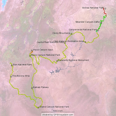
 back out to mile marker 17 where we intersected the highway from the east carrying our little sore-footed friend, and continue west up a less developed road. Although we had been moving up in elevation steadily since fording the Dirty Devil, we would soon start up the Henry Mountains in earnest. This leg of the Hayduke Trail offers the only taste of true alpine travel along the entire route. After having visited a variety of canyon systems and desert habitats, we were looking quite forward to a little 'vacation in the mountains'.
We had a bit of a slow Sunday afternoon hitch but eventually got a ride with a cool dude in a Toyota pick-up en route to Blanding. He had heard of the Hayduke Trail and reminded us of its reputation for difficult travel. He let us off in what seemed to  him like the middle of nowhere. Rainstorms were swirling all around us as we walked west, many descending right off the Henry Mountains now only a few miles in that direction. Fortunately, none of these storms struck our location and we stayed clean and dry as we approached an intersection of the road near the head of Butler Wash. We would then follow this drainage to the base of the Henrys.
 As the day came to a close, we began taking notice of the ever expanding views of the vast red-rock landscape below and to the east. More previously traversed terrain slowly opened into view with every little bit of elevation gained. If crossing the Henrys only offered a pictorial review of the vast canyon systems that had demanded so much from us these past few weeks, our efforts to gain the highest ridges would be well-rewarded.
Day 19
Monday, April 27
Start: Road junction near Butler Wash
End: Wickiup Pass, Henry Mtns
Miles: 9.4
Vertical feet gained: 2600
We quickly broke camp and soon found the drainage leading us out of Butler Wash and to the dirt road that we would follow  all the way to the highest pass over the Henry's. Although the road pulled steadily upward, we made decent progress as the surrounding vegetation took on a distinct transitional character. Pinon pines slowly gave way to more stately ponderosas and white firs. Aspen trees appeared in the bed of the creek now flowing alongside the road as we occasionally heard the call of wild turkeys off in the thick brush. A large mountain horned lizard scurried across the road and, as all horned lizards tend to do, patiently posed for pictures.
The road wound around the side of the mountain and would occasionally duck into ravines that had less sun exposure. ![]() We noticed that these within these little corners, the snow had yet to completely melt away and spring had barely arrived. We encountered several groups of the renowned Henry Mountain mule deer as we wound our way slowly up to a sheltered campsite on Wickiup Pass. By then, a stiff persistent wind had picked up and seemed to inject a noticeable chill into the thinning air.
We noticed that these within these little corners, the snow had yet to completely melt away and spring had barely arrived. We encountered several groups of the renowned Henry Mountain mule deer as we wound our way slowly up to a sheltered campsite on Wickiup Pass. By then, a stiff persistent wind had picked up and seemed to inject a noticeable chill into the thinning air.  From here, the road took a turn upward and into much deeper snow as it began a consistent climb up through the snowdrifts toward Bull Creek Pass. We decided that would best be tackled tomorrow and retreated into the tent as the temperatures dropped while the wind relentlessly whipped up into even stronger gusts.
Day 20
Tuesday, April 28
Start: Wickiup Pass, Henry Mtns
End: upper Sweetwater Creek Canyon
Miles: 7.8
Vertical feet gained: 2200
As the wind had not abated overnight, we departed camp dressed in the best cold-weather outfits we could throw together. This certainly didn't do too much to stop the penetrating wind and to make matters worse, the sun was melting the top layer of the deepening snow drifts. This caused us to 'posthole'  frequently as we attempted to cross the north-facing ravines enroute to Bull Creek Pass. As we steadily gained elevation, the wind increased to a persistent 20 mph and made the going even slower. We soon caught sight of the south summit ridge over which we had to pass in order to cross to the eastern flank of the Henrys. We decided to make a break toward the ridge to avoid what looked like a protracted and frustrating ascent over more unstable snow banks. Unfortunately for us, this turn exposed us to even more brutal prevailing winds. We crossed a few smaller summits enroute to the main south summit from which we would begin the descent but by now the wind had picked up into a sustained 40 mph and was gusting to around 60! (I used my trusty Kestrel 4500 weathermeter to make these recordings).
  Despite the nagging wind, which at times simply pinned us in our tracks, we couldn't help but notice the view which had opened up on the other side. We could see Capitol Reef NP far below and to the west, with its prominent trademark monocline known as the "Waterpocket Fold" running through the park along an extensive north-south axis. Great quantities of dust had been kicked up by the raging desert winds below and were beginning to obscure the
views both to the east and west.
Our immediate task was to gain some relief from the winds raging over the mountain ridge we had worked so hard to ascend. We noticed a newly installed cell phone tower and shack on the south summit and decided to make a concerted effort to get there and out of the wind. Caron got blown over a few times by the intense summit gale and by the time she made it into the cell phone shack, she was thoroughly frozen. Our coveted east-to-west mountain getaway had gone seriously south for the moment as we could now only think about getting off the ridge and into the protected warmth of the desert canyons below! Not surprisingly, we found we had cell service inside this shack so we made a few 'you'll never believe where I am' calls while the hurricane-force winds raged outside. We fixed some hot soup inside the shack and after warming up a bit, we decided to make a break for the exit route off this ridge. By late afternoon we had mananged to descend safely off the south summit ridge and eventually found ourselves next to another antenna shack from which we then dropped all the way to the floor of Sweetwater Creek canyon. We hiked until the sun began fading and managed to locate a decent campsite just above the very narrow wash.
Thank god the tempestuous crossing of the Henry Mountains was now behind us. I have never experienced such intense winds before but the Henrys are notorious in that respect. It seems the deserts east were doing battle with the deserts west and this little mountain range was caught up in a winless battle of intense air flow between numerous low-pressure centers. Although our passage across the Henry's was all too short, it packed an unbelievable punch that will not soon be forgotten!
Day 21
Wednesday, April 29
Start: upper Sweetwater Creek Canyon
End: Tarantula Mesa above Muley Creek Canyon.
Miles: 11.5
Our goal for today was to ramp up and spill onto the huge Tarantula mesa residing immediately west of the Henry Mountains. We travelled down Sweetwater Creek canyon and filtered water at what we thought might be the last appearance of flowing water. Desert creeks are quite unpredictable in their offerings of surface water. Unlike mountain streams, they rarely get bigger or wetter downstream. In fact, it is often more likely that the water will be available upstream as it tends to disappear beneath the deepening sand in the downstream stretches. We usually just follow the policy of taking water whenever it surfaces as it is not possible to predict where it will make its last appearance.
The widening canyon hosted a few major pour-offs so we decided just to reroute to the base of  Tarantula Mesa through the juniper cloaked hills after ascending to to the rim at the first impasse. From there we turned onto a road that quickly ascended to yield some pleasantly flat walking on top of the enormous mesa-- through some very scenic country as a bonus. Although we were back in familiar desert environs after having crossed the mountains, the landscape had a novel feel about it. The canyons, rather than slicing suddenly through deep layers of rock, were tightly nestled between vast and expansive mesas comprising sandstone caps sitting squarely atop thick beds of eroding grey shales. We also encountered a strange-looking solar-powered cattle tank on the mesa. I have no idea how this contraption works but it appears to be extracting plenty of water in this otherwise bone-dry habitat.
 After seven miles on this road, we abruptly left it late in the afternoon and navigated briefly to the edge of Tarantula Mesa overlooking the extensive Muley Canyon drainage. We were now poised for another harrowing steep descent down the canyon wall but that would wait until tomorrow's morning sun was upon us.
Day 22
Thursday, April 30
Start: Tarantula Mesa above Muley Creek Canyon.
End: Swap Canyon inside Capitol Reef NP
Miles: 13.1
Unlike the previous steep canyon descents we have previously experienced, the route down the edge of this huge mesa was well marked. We had no problem following it down and by now we were well aware that the best way to tackle these steep descents is to be deliberately slow and sure of every step. Soon we were delivered safely to the drainage below where we tried to make sense of the guidebook's directions on navigating the tricky landscape ahead.
We eventually found the stock trail as advertised and were now on a contouring route around the base of Tarantula Mesa, whose immense size was still being revealed with every slow mile we accomplished. Our goal was to find a break into Swap Canyon which was a whole level lower than Muley Canyon.  Unfortunately, although a number of springs appeared on the maps, they were either impossible to locate or severely fouled by cattle. So we were again running short of good water in the heat of the day. One such water source was a spring running down a narrow unnamed wash which we were following down to the confluence of yet another wash. Most of the standing water had evaporated leaving a thick, crusty salt deposit atop a slimy, muddy substrate. The concoction tended to entrap our feet beneath an organic salt/mud slurry in tight sections where we couldn't avoid stepping on it. Thoroughly gross and quite unlike anything I've ever seen before!
Rather than follow the guidebook's route which had us descending yet another steep canyon wall, we decided to navigate to the head of a shallow, easily descending wash that I had noticed on the topo earlier. It was located just to the west of the tricky landscape through which we were moving in order to find the route down Swap Canyon. I set the GPS for the coordinates of the wash, we found it very easily and then followed its forgiving course to the merge with Swap Canyon. I would suggest taking this alternate route as it is certainly easier to locate and to traverse (see Route Commentary). Like Swap Canyon, the drainage has a set of springs within it but like all the springs we've encountered earlier since entering the mesa country, it was severely fouled by cattle. So we thought we'd try one final time to locate usable water up in Swap Canyon before filling up with now much-needed water.
Our efforts there were also in vain as this water had also been rendered quite unusable by wallowing bovines. What makes this situation so frustrating is that there is no lack of water sources in the area, it's the action of the cattle that eliminates the availability to the human traveller. Where'sthat ingenious spring maker whose handiwork we appreciated earlier in Poison Spring? Quite frankly, I think it should be up to the cattle grazers themselves to protect these water sources for human consumption. After all, we as taxpayers are subsidizing the profit they make from fattening up their cattle on public lands. But what's done is done and it should be noted that there are now few, if any at all, good water sources for 30 miles or more beyond Sweetwater Creek. Not good news for Hayduke hikers.
We were forced then to take on bad water once again. We limited ourselves to one liter each because of the generally unhealthy alkalinity and dissolved organic content of this water. With disdain and resentment at having been foiled three times by the cursed BLM bovines, I rounded the next bend beyond the Swap Canyon Spring and found myself abruptly face-to-face with one of the offending parties. However this bovine was of the American bison variety! He saw me and turned tail but fortunately one of his buddies was frolicking in the high grass and didn't notice me until I captured a few seconds of his antics on video. I knew about the expanding wild herd of buffalo in the Henry Mountains but never expected to meet up with one in the lower canyons. In fact, we had been following a small herd down Swap Canyon all along but now engaged them in hotter pursuit with video ready to roll.
Somehow, as I was hunting buffalo along a stock trail of their own making, Caron and I became separated and couldn't seem to reconnect. I abandoned the buffalo hunt and tried to locate her by backtracking and then following her forward tracks from a location where I surmised we both had been. Eventually, about sunset, it became clear that she was ahead of me and after another hour I happened upon her campsite, well within the boundaries of Capitol Reef National Park. Neither of us was too terribly pleased with the other so we eventually just had to forget about the incident and concentrate on our impending needs, like the good water we had buried only 4 miles away in Capitol Reef NP. Once again, we retired for the night in great need of decent water.
Day 23
Friday, May 1
Start: Swap Canyon inside Capitol Reef NP
End: Lower Muley Twist Canyon
Miles: 10.1
The first of our only two backcountry caches now awaited us a few miles ahead but we first had to ascend 600 feet up the notorious Burr Trail switchbacks. After this climb, we then had to unearth what we recalled was a very deeply buried tub of goodies near the Lower Muley Twist Canyon trailhead. Since the Burr switchbacks face east, we endeavored to get started on them early in the morning before the sun was fully up and eliminating the pockets of shade that might be very helpful on the ascent.
In that regard, we were a bit late but not badly so. On the way up, we got our first views up close of the famous Waterpocket Fold of Capitol Reef NP. All the prominent and well-known geological layers of the upper Colorado Plateau (the Navajo Sandstone, the Kayenta formation, the Wingate Sandstone, and the Chinle formation) are here intensely folded and compressed tightly together by this single bout of strongly upwarping tectonic forces. The geologic exposures along this famous fold in the earth's crust alone are sufficient to warrant a trip to this under-appreciated national park.
We finally topped the fold and trotted over to the pinon pine tree that marked our cache location. Easy enough. Pinpointing the exact spot we buried it was another matter. Being even more parched than last night and in dire need of the cool water, which was now merely a mysterious arm's length away, did not seem to inject any logistical improvements into our search. Finally, and with great relief, we struck liquid gold and pulled up the water cache for a vitally needed long drink of water. It was actually cold, too! Being placed in the shade and buried deep under tightly packed soil, the tub had acted as a miniature refrigerator over the past few months. Even the candy bars were rock solid and fresh. Despite these advantages, I think we should avoid such a deep burial in future caches as the exact site was somewhat difficult to relocate and resulted in some overly anxious conjecturing.
We took a good long break in the shade of the pinon tree as we sorted through our pack contents and decided to leave some of the cold-weather items behind for reburial. We wouldn't need these as most of the remaining mileage is through hot canyons.  We also surmised that we have been routinely overstocked in the food department for every leg of this trip. This was mainly due to skipping dinners and breakfasts on occasion and by the enormous proportions we originally attributed to each meal. So we streamlined our food rations as well. We finally headed out around 5 in the evening and figured to get in about 6 or 7 miles before setting up camp. This mileage went amazingly fast for little did we realize, in leaving behind the grey and yellow mesas and the rugged Henry Mountains to the east, we were about to enter some of the most wildly beautiful canyon country on the Hayduke.
Total Hayduke miles: 262
Hayduke canyon count:
Butler Wash (up)
Ridge-based crossing of Henry Mountains
Sweetwater Creek Canyon (down)
Muley Creek Canyon (down)
un-named wash to "good springs" (down)
un-named wash away from "good springs" (up)
un-named wash into Swap Canyon (down)
Swap Canyon (down)
Routing commentary:
1. We found that breaking off the road to Bull Creek Pass to intercept the south summit ridge would be preferred in the face of postholing along the road to the pass. Do this about a mile from the pass and the route is very obvious.
2. Rather than descend back into Sweetwater Canyon pass the first pour-off and then have to redescend and then reascend, we set a GO TO point for the Tarantula Mesa road intersection and strolled through the pinon-junipers hills until arriving at the intersection.
3. While trying to ascertain our position on the maps in order to make the proper descent into Swap Canyon, we noticed a very negotiable ravine that descended gently to merge with Swap Canyon. If you have the USGS 7.5' map, find the "Swap Canyon Springs" label on it. The little wash entering from the north is what you want. This drainage is easily and naturally entered from the "high ground" area you are maintaining while contouring around the base of Tarantula Mesa.


We visited with Caron and Jeff while hiking down the Escalante River on May 6. They were headed to the junction of Coyote Creek for camp that night. They seemed to be healthy and in good spirits. We enjoyed talking about otters, lizards, cows, Grand Canyon Trust, and other important matters of life.
ReplyDeleteAmy & Jim